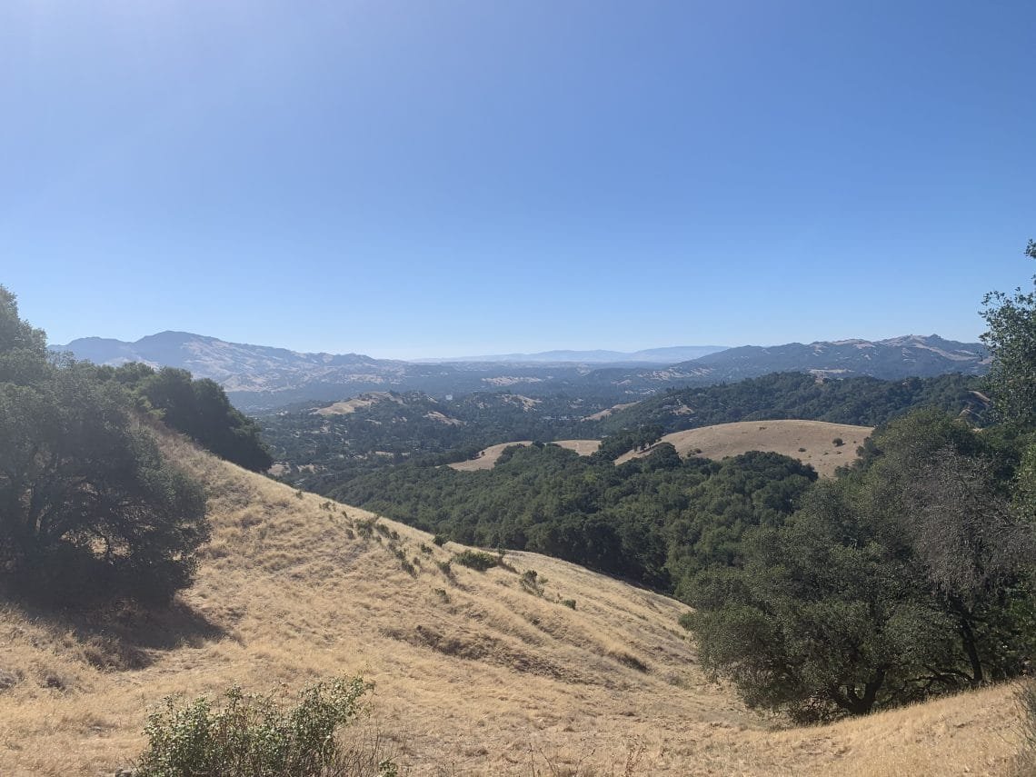
With three weeks to go until the JMT, I know I have to keep active. Since I hadn’t been able to get to the Briones Regional Park during the COVID-19 situation, I decided to do the Briones Crest loop.
The day was forecast to be very hot, so I got a early start. The Crest loop would allow me to do the return to to my Jeep from multiple trails, so I could decide how far to go or how much heat I had to put up with until the heat made me run back to my air conditioned Jeep. 🙂
The initial climb up the the crest was the hardest part, but was a good workout. After that it was mostly went along the crest with a little up and down hiking along the way.
As the morning went on, I was feeling pretty good and kept going around the loop. Even as I reached the last major trail where I could take a direct line back to my Jeep, I decided it was still early (although it was getting pretty hot) and I would continue at least until Russell Peak.
I took a brief rest there and decided to finish the loop via Hidden Valley Road. It was only the second time I had done that full loop and I’m amazed I did it in the heat of that day.
A little over 9 miles, so not that bad. Only the heat made it a bit uncomfortable.
Two weeks to go. Some people would try to take it easy, but I know from experience that I can’t completely relax before a big hike. I’ll have a couple hours in Tuolumne Meadows the day before my JMT trek starts to do some short hiking, but having some hikes in the weeks before is also useful in preparing my body for the hell I will subject it to (shhhhh… don’t tell my body).
So I decided to take a crack at re-doing some of the trails at Mt Diablo State Park that I’ve done prior to 2020 and that I now hope to complete before the end of 2020 so I can say I did all trails in this park in one calendar year.
I decided the area of the park accessed from Morgan Territory Road was the logical choice. It had a lot of intermingled trails, but it looked like I could navigate a path that would cover all the trails I had hiked prior to 2020 in one day if I did the route right. And my body cooperated.
I started up Morgan Ridge Road and then moved onto Highland Ridge Road. Then a biggish detour to do a part of Sulfur Springs Trail.
Then I looped around to Amphitheater Trail. Here I did have to go up the start of the trail about a third of a mile (and about 250 feet to climb) and then double back to cover that part.
Then I had a lunch break in the ‘Amphitheater’. It was an interesting area with large rock formations that had the appearance of a stage and a bowl of seating around it. After a break, some food, and a Diet-Coke I did a little rock scrambling. Nice view and a great place to practice my scrambling skills.
It was still pretty early (10:30am or so), so I continued my planned route to Tassajara Creek Trail.
Here I made a boo boo. The only other time I had hiked this trail, I had taken what I thought was the proper trail. So when I started down during this hike, I followed my old GPS track. While the trail I followed was decent, it was fairly primitive. I had assumed it was just not heavily used.
About a quarter mile down, I saw my mistake. A very well worn trail to the north of the ‘trail’ I had been using came into view and it became apparent that I had taken the wrong trail down.
Crap. That does mean I didn’t actually finish all the trails back in June. I could just lie and say I did it, but to be honest with myself I would have to climb up the real trail and re-descend.
I wish I was a less honest man. 🙂
So I added about a 2/3rds of a mile to my distance and a couple hundred more feet climbed and descended that day.
This trail then climbed up the side of a large ridge through a chasm cut by a stream (dry at this point in the year). Fairly steep, but at least it was shaded by trees.
Then it transitioned to a more horizontal trail that wrapped along a ridge, unfortunately in the sun most of the way (it was getting pretty toasty by that point). I passed Bob’s Pond (actually more like “Bob’s Indention in the Ground” in mid-July).
As I finished that trail, I headed down the last new trail to hike in that area: Jeremiah Creek Trail. Fortunately, it had a decent amount of shade.
Reaching my Jeep I sighed at the 11.5 miles hiked that day. Seemed like more, but I did manage to wipe a large area on my list of Diablo trials to re-hike this year.
The next day, I was either going to do a big bike ride, not do anything, or do a short bike ride. First thing in the morning, I didn’t feel like doing anything. Then after breakfast I had the energy to go out for short bike ride.
Somewhere along the ride, I decided to go down the Contra Costa Canal Trail through Pleasant Hill. I don’t get down that way often and never got that far (on bike or foot), so figured it would be a nice change of pace.
At some point, I decided to check out the northern parts of this trail and looked at a map to see how far it went. I was a little amazed that it went all the way to Highway 4. Still, I had brought a bottle of Gatorade along, so it wasn’t out of the question to do a longer bike ride.
Although I did find that the northern part of this trail got very hilly, so there was a lot of up and down. But most of the time I could coast down one hill, then use that momentum to get up the next one. So, it wasn’t that bad overall.

I ended up doing about 19 miles. Not a record for me (not even half of my record, since I did 45 miles doing the entire Iron Horse trail earlier in the year), but a decent bike ride.
Since the Contra Costa Trail runs right past my home, I might have to use this part of the trail more often to get some more variety. There’s a section that runs the other direction towards downtown Concord that I never bothered to ride on yet, as well.
On the last Saturday before my big JMT trek, I… did nothing. I had planned to take my Bike to Mitchell Canyon in Mt Diablo State Park to do some hiking there, but when I woke up I didn’t feel like doing that. Even after breakfast, I just didn’t seem to feel like doing a hike or bike ride or much of anything that day.
So after having a Zero Day at home, I did have the energy and willpower to go hiking on Sunday. I skipped the bike ride and drove to the park. Since I was getting my usual early start, I couldn’t start from Mitchell Canyon since the gate opens at 8am (although sometimes it’s open by 7am).
So I started from Regency Drive. Unfortunately, the NIMBYs there had forced the city to completely remove any parking near Regency Gate. So, I had to find a place to park and walk a little further to start my hike.
In my quest to re-hike the trails that would allow me to complete hiking ALL trails at Mt Diablo during 2020, I decided to go up to Twin Peaks and Eagle Peak. Unfortunately, there were 4 trails that I’d need to hike to get up to the ridge between these two peaks, but doing that in a single hike was mostly impossible and would require a second trip tot he area.
So, I went up the nearest trail (Eagle Peak Trail), took a little short detour to Twin Peaks, then mad ehte slog up the ridge to Eagle Peak.
I had originally planned to go up Mitchell Canyon Trail and then do this ridge from the east, but with my starting point changing and it already gettign pretty hot by 9am, I decided taking the shorted Back Creek Trail was the better choice. Going the other way, could add 4-5 miles to my day and decided I could do that route at a later date.
So I returned to my Jeep along a few small sections of trail that I’d have to re-hike anyway, so all was good.
6 days to the JMT.


Comments by WanderingJim
JMT 2020 Day 3
"I'm afraid I have no idea. Not really a fisherman, so don't..."
JMT 2020 Trek Day by Day
"Yeah, but with 9,000 pictures, it's hard to label each one..."
Kilimanjaro – October 2019
"Everest Base camp is on my list too. Mostly since I know..."
Kilimanjaro
"You started hiking with Kilimanjaro first? Even I worked my..."