Goal for the day: Muir Trail Ranch!
It was cold.
Very cold.
I didn’t expect it to be colder than it had been at Muir Pass the night before, but it was.
Poking my head out at first light, it became obvious why it was much colder than it had been the previous morning.


Being a meadow, the extra moisture in the air caused FROST to form over… everything.
Grass, bushes, some of the trees, my tent poles, my bear canister, and my extra water container (which was also half frozen). Even my beard and mustache frosted over when I breathed the cold air in and out.
It was that cold.
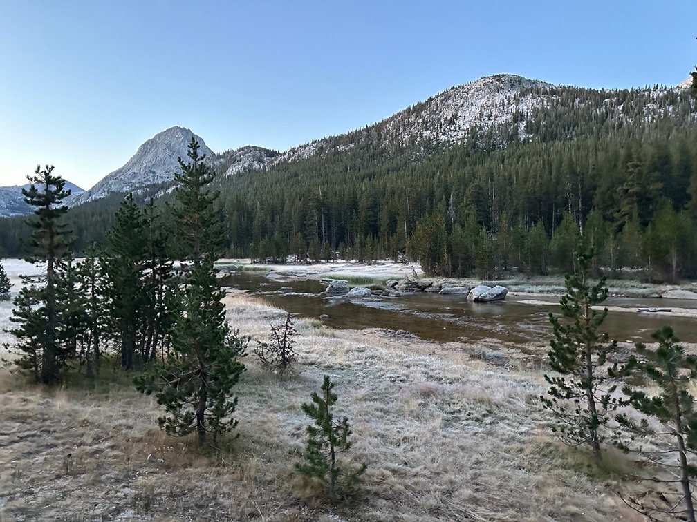


I knew the angles in the meadow weren’t the greatest for spectacular morning light, but there was some light as I ate a hot breakfast from inside my tent and sleeping bag.
It was that cold.


The the goal for this day was to get to Muir Trail Ranch, which marked the START of the hardest section of the JMT when hiking Southbound.
Going Northbound like I was this time, it would be the END of the hardest section of the JMT. The four nearly 12,000 foot passes were behind me (five if you counted Kearsarge Pass).
But it was very cold.
The last time I was at Muir Trail Ranch, I took the opportunity to take a Zero Day near the ranch. This time, I hadn’t decided at that point if I would take one. After taking a Zero Month, you’d think 8 measly days on the trail wouldn’t exhaust me.
Did I mention it was the hardest part of the JMT? Looking at my scores for the four passes on this part of the JMT, it does look like my non-scientific grades for climbing these passes from the South or North are very close to being the same.
Maybe just a little easier going Northbound, but my legs and feet insist they are both horribly painful and never to be done again… or else.
But my body was too cold at that time to care about how hard climbing and descending the passes that were behind me were. So, what should I do?
Naturally, I used my Inreach to check with Muir Trail Ranch if they happened to have any cabins available for the night. It took a few back and forth messages, but they said they may have a cabin available. They’d know more later in the day.
That was enough to give me a reason to get out of my sleeping bag, pack my gear, and head North once again on the trail. It was a little later than normal when I got back on the trail though. 7:45am.
It was still cold, as proven by the frost continuing for most of the rest of the meadow.

The frost disappeared after about an hour of walking along Evolution Creek.
It was still… chilly by the time I had to cross a wide (but shallow) area of Evolution Creek. The last time I crossed this creek, I just walked across and let my boots get damp. Then it was late in the day, it was warm, and I knew I would be camping in the meadow ahead.
This time, it was cold (both the water and the air). It would be best NOT to get my boots wet early in the day when it was so cold. For some reason, this part of the creek didn’t have any big rocks or fallen trees that hikers used to help cross the creek. But after thinking about it, I have to think that this ‘creek’ must flow VERY heavy during the spring snow melt and the entire flat area around this part of the creek must flood. They even had an alternate path for the JMT/PCT if the regular path was impassible due to flooding. That heavy flooding would likely push any rocks or logs put into the creek away.

Normally, I would have taken off my boots and socks and waded across and then dried my feet off after crossing the water.
Have I mentioned it was still cold?
I didn’t want to wade through very cold water on a very cold morning, so I kept my boots on and carefully choose my path across and made it (almost) the the other side without getting water over the bottom two inches of my waterproof boots.
But my last two steps were rushed due to the creek getting a little deeper on the far side, so I ended up with a little dampness on the exposed parts of my socks and the lining of my right boot. Overall, I think it was still better than wadding across the cold creek with bare feet.
After the crossing the creek, the trail started to descend a very steep cliff down to Evolution Valley. Climbing up this cliff from below had been very annoying and traversed some very badly designed switchbacks that seemed to have several stretches that lost elevation as you ‘climbed’ them.
Going down them was much easier. The cascading water of Evolution Creek followed the trail down, giving you several nice sights of the cascades as you went down (and giving you an excuse to pause when climbing up so you didn’t look like you were exhausted climbing the switchbacks). 😀

As Evolution Creek merged into South Fork of the San Joaquin River , the most challenging crossing of the entire trek lay ahead of me.
A bridge that allowed hikers to cross a very fast flowing part of the South Fork of the San Joaquin River had been twisted and utterly destroyed during the Winter of 2022-23. The snowfall that Winter had dropped 200% PLUS of the average snowfall and caused a lot of damage both in the wilderness and in more civilized areas. I wouldn’t even have been able to hike this part of the PCT/JMT in August the previous year.
The bridge had been completely removed in preparation for replacing it, so you either had to find another way across the river or use a VERY long detour. That detour climbed up over Bishop Pass, and then down to Piute Canyon before it rejoined the JMT/PCT. It was almost 40 miles of hiking to take that detour unless you got lucky and got a ride between the Bishop Pass Trailhead and the Piute Pass Trailhead or got a ride into Bishop to rest and resupply (which many PCT hikers did over Bishop Pass).
If I had continued North in July from Kearsarge Pass, I had planned to use one of the reported fording locations north of the missing bridge. The river at that point (even in late August) was flowing fast through a deep grove cut through the granite. It was not to be taken lightly. There were enough recent trail reports describing various places to ford the river North of the bridge’s former location that I was hopeful I could safely navigate it. Some of those reports said it was at knee level and some at waist level. The former I’d done before, the later would be a new experience. If I couldn’t cross the river, I’d have a long hike back to Bishop Pass to exit from the wilderness.
But in the end, it was the fact that the detour would skip 25 miles of the JMT/PCT AND make me miss Muir Pass AND McClure Meadow that made me decide the risk of fording the river based on the trail reports would be worth the risk.
The risk in July, that is.
Days before my August re-start at Kearsarge Pass began, it was announced that a temporary construction bridge near the old bridge site had been installed and it was okay for hikers to use it (at their own risk and as long as they didn’t disrupt construction work on the new bridge).
That news in August added some motivation to my decision to re-start my trek and, in retrospect, my decision to not continue North in July was probably at least partly due to concerns about the missing bridge and dangerous ford.
So, I had woken up that morning without any concerns about this river crossing.
It was still cold, though. 😀


Then I saw the construction site…

And the temporary construction bridge…

And the ‘use at your own risk’ sign…

I did hope that other hikers would cross it so I could see if it collapsed for them, but two hikers had just crossed it and were shaking in their boots in terror.
Well, not really. They were just taking a brief break before continuing Southward the way I had come from.
Well, it HAD to be safer than crossing the river below by wading.
Probably…
It looked pretty sturdy and seemed stable as I started.
Until I reached the middle.
Then it started to feel like the very bouncy Woods Creek Suspension Bridge. And that was made out of a large steel truss, thick cables, and perforated metal planks.
The temporary construction bridge was made out of thinner cables, wood planking, and was suspended by large bolts drilled into the granite on either side of the bridge.

I made it safely across by taking short breaks to allow the bridge to stop bouncing, but not long enough for the bridge to buckle under my weight (200-ish plus maybe 35 for my pack). When I reached the end, I found myself facing solid granite cliff side. Who the heck designed this temporary bridge?
Fortunately, there were steel rebar loops embedded in the cliff side to allow you to climb up to the trail above you. It was tricky with a backpack and my trekking poles, but I did make it safely to the other side with most of my wits intact.

Smooth sailing from there down to Muir Trail Ranch!

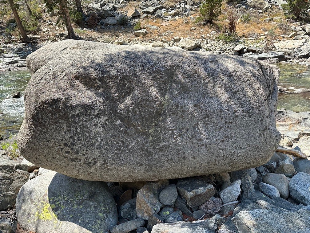
I paid a visit to the Muir Rock along the trail. It was engraved during the construction of the JMT in 1917. The engraving is hard to read in the shadows and reads “1917” on top and “Muir Trail” on the bottom.
I reached the bridge over the Piute River shortly after and took a brief rest there. That was when I got a message on my Inreach that there was a cabin available at the Muir Trail Ranch (MTR).
The rest became much briefer. The knowledge that I would have a real bed in a real wood cabin to sleep on was very motivating. Who cared if it was freezing overnight again?

Me. A little bit. 😀

When I saw the inside of the cabin, I was suddenly less excited.

Oh, that was just the inside of a historic cabin built during the construction of the JMT and called the Muir Hut. Just another quick sight to see on the way down to MTR.

I reached the junction where the JMT/PCT met the Florence Lake trail, which would take me to the ranch. I did have the option of continuing North on the JMT/PCT, but that would be 2 miles of climbing upwards followed by an extra 1 mile of descent to the ranch. The Florence Lake Trail would be mostly level with a few bumps and dips. It would add a little extra hiking to get back to where I left the JMT/PCT when I restarted my hike, but I felt it was worth it to get to my resupply package (and the Golden Oreos and cans of Diet Coke inside it) quicker.

Did I say smooth sailing?
Not too far from the ranch, I must have been distracted of the thought of drinking a Diet Coke that I tripped on a tree root and banged my head on a rock.
Hit it hard.
Concussion-level hard.
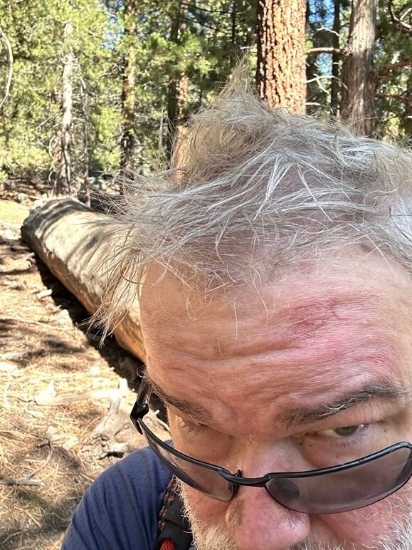
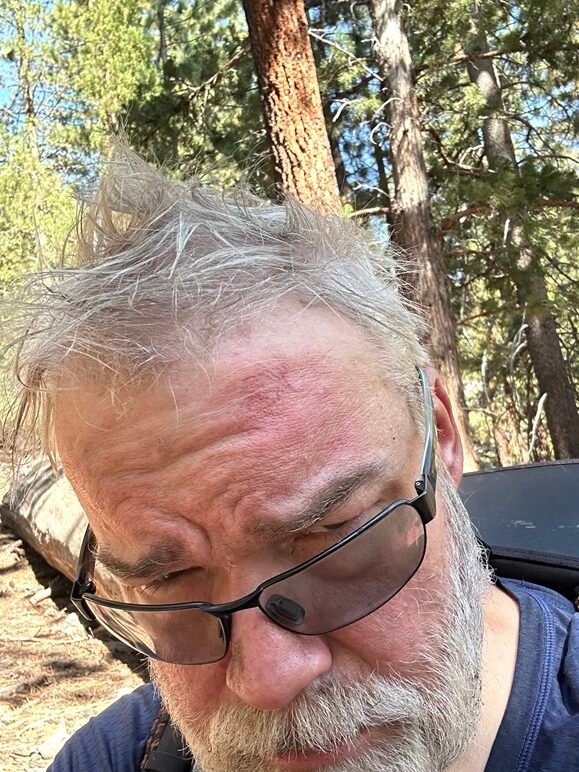
No blood or pieces of skull poking out, just a huge red bruise on my forehead. The messy hair was just a result of wearing a hat, sweat from my head, and was normal for me on any hike (see any of my photo albums for proof). After taking some selfies to check for any major injuries, I continued towards the ranch.

I reached the resupply area, got my resupply, and then paid a lot of money for a unheated cabin in the wilderness, with no electricity, no cable TV, no pizza, and no shower.

After 8 days on the trail over five 12,000 foot passes, it was HEAVEN ON EARTH!
The sunset from one of the hot spring pools wasn’t bad either.

This was a much needed and welcome rest from the trail. The hardest part was behind me, but if I wanted to continue a nice rest would be very helpful.
It was cold that night, but I didn’t care. I had walls, a real mattress, and warm blankets!
Goal for the day: Success!
Day 12 – 12.5 miles – 8 hours 30 minutes
PCT section H – 91.7 trail miles out of 175.5 total miles

(mileage and time approximate and based on GPS tracks which may not be exact and include diversions from the trail)




Comments by WanderingJim
JMT 2020 Day 3
"I'm afraid I have no idea. Not really a fisherman, so don't..."
JMT 2020 Trek Day by Day
"Yeah, but with 9,000 pictures, it's hard to label each one..."
Kilimanjaro – October 2019
"Everest Base camp is on my list too. Mostly since I know..."
Kilimanjaro
"You started hiking with Kilimanjaro first? Even I worked my..."