When at first you don’t succeed… try… try again.
After my equipment problems in December left me with wet feet and ended my winter trek through Yosemite’s wilderness early, I had to decide to either never do winter hikes again or come up with a solution. I chose the later. After my attempts to repair my current boots failed I did some research and tried out a couple of new pairs of boots. Then I headed back to Yosemite once there was clear weather forecast for the rest of January.
Normally, I’d prefer to break in new boots with some shorter hikes, but didn’t want to wait any longer. So I packed a number of different socks and even some thin vapor barrier socks, so I could adjust my footwear as needed along the way.
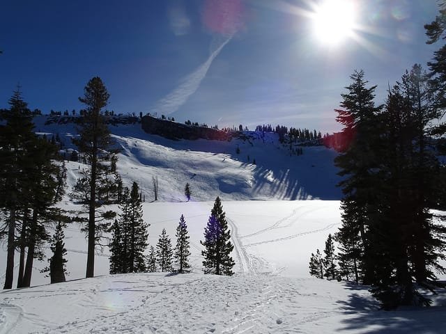
My goal was still to get to Ostrander Lake, but I decided to go down Glacier Point Road and then go over Horizon Ridge to reach the lake. That would be a harder hike, but I didn’t want to retrace my exact route from December. I would still have the chance to change my mind when I got to the Bridalvail Creek trail, but Horizon Ridge would give me new views to enjoy and new challenges.
One big difference from my December attempt was the weather was a lot warmer. I was down to a single shirt and no jacket later in the day as the temperatures were in the 50s and maybe even the 60s when in the direct sunlight. I wish I packed my lightweight sun hat, so had to get creative and use my buff I always keep in my pack to keep my ears warmer and provide some protection from the sun. Never had frost form on my tent walls overnight either.
The first part of the hike along Glacier Point road was fairly easy since they groom that trail. Once I got to the Horizon Ridge trailhead, I had my first taste of the steep climb that would be ahead of me. It was a challenge, but I made my way up the first steep section before I hit Pohono Meadow and got a brief break from the steep terrain.
Then I hit Horizon Ridge proper and the steep climb resumed. Slow going, but I made my way up.
Then part of my left snowshoe broke. Turned out a part of the hinge where the boot binding attaches to the frame had popped off during a tough spot where my leg got twisted. I was able to snap it back on so I could continue, but there was a crack in the piece so it popped off again.
That could have ended my trip there and then, but it was getting late and I was already looking for a spot to setup my tent for the night before that happened. I had hopped to get higher along the ridge to get a grand view, but I did find a spot with a view of the back side of Half Dome, Mt Hoffman, and Mt Star King. I set up my tent, had my dinner, and took a look at the snowshoe.
Fortunately, I was able to use some duct tape from my emergency kit to secure the broken piece to the hinge so it should stay in place and allow me to continue my trek. I wouldn’t know for sure until I started hiking again the next day.
Unfortunately, the skies were overcast that evening so there wasn’t a lot of light from the sunset to enjoy, but the morning was clear and I did get to see some light splashing across Half Dome and the other parts of the Clark Range that I could see.
I packed up my tent and gear and started up towards the top of Horizon Ridge. It was slow going again due to the steepness, but as I neared the top the trees started to thin out and I was treated to a grand view of the entire Clark Range.
Based on my pre-trip research, this was actually one of the possible camping areas I had been thinking of stopping for a night. Since it had already taken me a good deal of time to reach that point with my full gear and there was an even steeper climb ahead of me to reach Ostrander Lake, I decided to make this my second night’s campsite.
But it was still morning, so I decided to make Ostrander Lake a day hike from here. So I left my tent, sleeping bag, and any excess equipment I wouldn’t need there. I kept my food, emergency kit, and some extra layers of clothing in my pack and headed toward Ostrander Lake.
This did limit my options on what to do the next day since I couldn’t choose to continue over Merced Crest to return to Badger Pass, but the view was too good to pass up and I wasn’t excited about hauling my full 40 pound pack up the steep trail to the lake at that point.
Making my way around the other side of Horizon Ridge, I decided I had chosen wisely. The last mile and a half was a very steep climb up around 600 feet. Hiking in summer, this wouldn’t have been that bad even with my full pack (I have done much worse climbs), but in winter it makes it particularly slow going.
But I finally made it to the lake and got my first sight of Ostrander Lake and the ski hut. Goal!!


I checked out the lake and ski hut for a while. It’s a nice building and even has sit down toilets to use (although not flush toilets, naturally). Those are few and far between in the wilderness.
Many skiers use this as an overnight stop and I might have been happy staying there a night as well, but I couldn’t get a reservation for that night before I left (they had reopened it even during the government shutdown a week earlier). I assume if I really wanted to say or if it was later in the day and unsafe to return, they would have probably let me stay (the ranger wasn’t around, so I’ll never know).
So I refilled my water (after boiling it using their gas stove) and made my way back to my tent to enjoy the light show at sunset.
I had chosen wisely. It was a clear night and the light danced across Half Dome and the Clark Range. Since it wasn’t that cold, I even had a chance to enjoy it outside of my tent (usually in the winter, I spend most of my time in my tent and just poke my head out to see the sights).

After a decent night’s sleep, I then enjoyed a stunning sunrise with the light descending in sheets down across the peaks all along my view.
I even got a rare chance to see the shadow of Mt Star King grow across the backside of Half Dome as the sun rose. After giving me a show, the clouds started to move in and most of the morning was spent under gray skies.

Then it was time to pack up and head out. But where?
Since I had decided not to take my full pack to Ostrander Lake, I couldn’t return via Merced Crest and returning via the Bridalvail Creek trail wasn’t that appealing (a little longer and I’ve seen it already). Since it was mostly downhill from where I was, I decided to return down Horizon Ridge.
Once I hit Glacier Point Road again I could have gone down towards Sentinel Dome and Glacier Point and spent another night somewhere in that direction, but I decided what I had done was enough for this trip. I had already done a winter trek down to Sentinel Dome and Glacier Point two years earlier, so there wasn’t much incentive for me to spend another night or two out there. Also, with the skies still having a lot of clouds I didn’t think the sunset would be as good as it was the previous night.
So I made my way back to Badger Pass and had some pizza on the way home to celebrate my successful trip.
20 miles through the winter slopes of Yosemite made for a tiring, but spectacular trek.
The new boots kept my feet dry, but I’m not yet sure if the fit is correct. Had some pain in my toes and feet during the trek, but that could be normal break-in pain. I’ll have to do some local hikes to make sure they are worth keeping.
Not much wildlife in the winter. A few birds, 2 crows that were waiting for me to leave my campsite (you can see them flying through some of the pictures), and I did see what I thought was a wolf as I drove out of the valley. It seemed too big to be a coyote, but upon doing some research it was probably a big mountain coyote.
The best photos, sunrise/sunset time lapse movies, and mountain peak identification pictures:
All the rest of the photos:


Comments by WanderingJim
JMT 2020 Day 3
"I'm afraid I have no idea. Not really a fisherman, so don't..."
JMT 2020 Trek Day by Day
"Yeah, but with 9,000 pictures, it's hard to label each one..."
Kilimanjaro – October 2019
"Everest Base camp is on my list too. Mostly since I know..."
Kilimanjaro
"You started hiking with Kilimanjaro first? Even I worked my..."