After my big hike to see the first sunrise of the year at Redwood Regional Park, I decided to try a new trail yet again to finish off the long weekend.
East Bay Municipal Utility District (EBMUD) has a large number of open spaces with trails, but you need a special permit to use the trails. Because of some nice trials near Briones Regional Park and other EBMUD trails that I had some interest in, I had been thinking of getting a permit. But when I found that there are a good deal of EBMUD trials around my new home in Moraga, it made even more sense for me to get a permit and hit the trails.
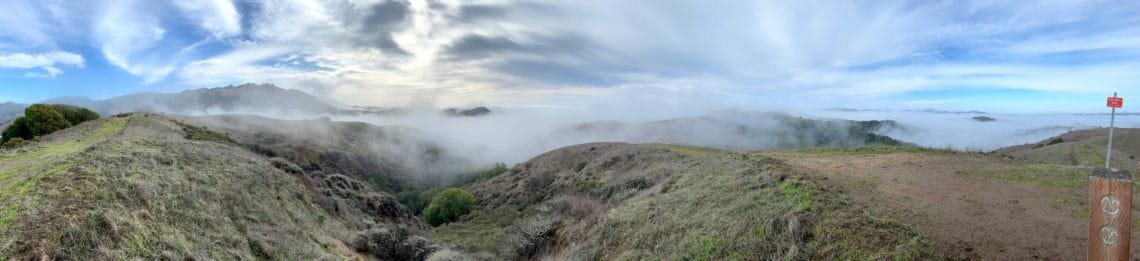
So after buying the permit online, I headed for Rancho Laguna Park and the Rocky Ridge Trailhead. The plan was to follow the Rocky Ridge Trail to the Carr Ranch Loop Trail. It should have some nice views, although I started hiking with a thick fog covering the ground so there wasn’t anything to see. Hopefully, the fog would burn off as the sun rose higher.
The rain a day earlier also left some muddy and slippery spots, but I made it to the junction with the loop trail okay. As I climbed up the hills, the fog started to lift. Or more accurately, I climbed above the fog. 🙂
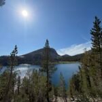
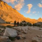
The views were very nice once I could see something. Even the low layer of fog all around me also gave some nice ‘sea of clouds’ views of the surrounding hills. I could see the Oakland Hills, ridges of Briones Regional Park, and Rocky Ridge above the fog. Very nice.
As I started down, I found that EBMUD was living up to it’s name. The rain the previous day left a lot of muddy trails and my boots must have gained 4-5 times their normal weight at times. I had to stop and scrape and stomp the mud off often, while still being careful not to slip on the mud.
Maybe I should have targeted a paved trail today after all. 🙂
After rejoining the Rocky Ridge Trail, I could have gone and done the Rocky Ridge Loop. After thinking about it, I decided to return to the trailhead. The mud was becoming an issue and having to climb up to 2,000 feet at that point wasn’t that attractive. I could do that loop in the future, even from the Las Trampas side if I wanted to.
So I headed back, still picking up a lot of mud along the way. Putting my muddy boots and trekking poles in a bag, I rolled up my muddy pant legs and drove home.
So, two brand new hikes to start the new year. Maybe I’ll do nothing but new trails this year… Naw… that’d be hard to do with all the great trails at my disposal.
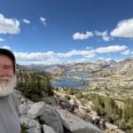
The next weekend, I decided to do the Rocky Ridge Loop I hadn’t felt like doing the weekend before. I could have started from the same trailhead, but that would add a lot of mileage to the day. So I decided to start from the Las Trampas Regional Park’s Bollinger Canyon Staging Area. It was a steep 900+ foot climb up to the ridge, but once up I enjoyed the view. I started by going across to a little rock outcropping that had a great view of the west, then went up to a spot called Rock 2.
At 2,024 feet, Rock 2 was the high point of the ridge and for my day. Some nice views, but the radio tower marred the view a little.
There is a tree stump and broken bench surrounded by a broken fence. It looks like the fence may have been put there to protect the tree when it was alive, but lost the battle. I’ll have to see if I can find some info on that.
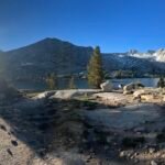
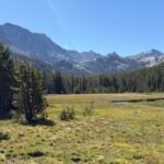
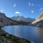
From there, I headed north to start the loop. Some more great views of the area as I descended to around 1,000 feet along the west side of the ridge. I was glad I waited till this weekend to do this ridge, since the fog the previous weekend would have muted the views. Without the fog, I could see the very large area of undeveloped land around me. Very inspiring that there were still such large new areas for me to explore.
I considered going over to Ramage Peak, but wasn’t sure how accessible it was (it is on private land) so decided to just continue the loop.
Unfortunately, I had to re-climb up 1,000 feet to reach the high point of the ridge again, but got a lot of good views along the way.
I took a break at a bench that was beside a nice rock outcropping that had hawks and/or vultures circling around and swooping down the hillsides in search of dinner.
Finishing the loop, I had to decide how to get back to my Jeep. I could go back the way I came up, but if I headed south for a little bit there was a trail I had never hiked on. It would be almost 2 miles more hiking, but mostly downhill.
It was a nice hike (although I did have second thoughts about a mile into the 2.8 mile descent 🙂 ) and I did see a couple Coyotes on the way down.
So two big hikes in 2021 and both were in new areas I had not explored before. Ring in the new year with new hikes!
I started the next weekend trying to do something I had wanted to do ever since moving to Moraga (a whole month ago): Bike the entire Lamorinda Loop trail.
This bike trail (although I guess you could hike it as well) is a 17.5 mile loop from LAfayette, down to MORaga, and ORINDA. Combine the three city names in that triangle and you get LAMORINDA.
Naturally since I live in Moraga, I started from there. After a 3/4 mile ride down to Moraga Commons Park, I started down the Lamorinda Loop trail until it met Moraga Way, one of the 3 main ways to leave Moraga. One lane each way with bike lanes on each side. There are a few spots where the bike lane is a bit narrow, but it’s mostly a good ride… well except for the gradual 300 foot climb I’d have to do. That climb was the reason I decided to do the trail in the clockwise direction: Get the big climb over with.
This would be the route I’ll take to Orinda BART station when I start commuting into the City in the future (who knows when that will happen), so I had already done a full bike ride to the station and back. That’s why I celebrated when I reached the high point and could (mostly) coast down to the station. 🙂
From there, I headed East on St Stephens Trail, which paralleled the freeway (fortunately with a fence protecting me from the cars blowing past at 74 miles an hour).
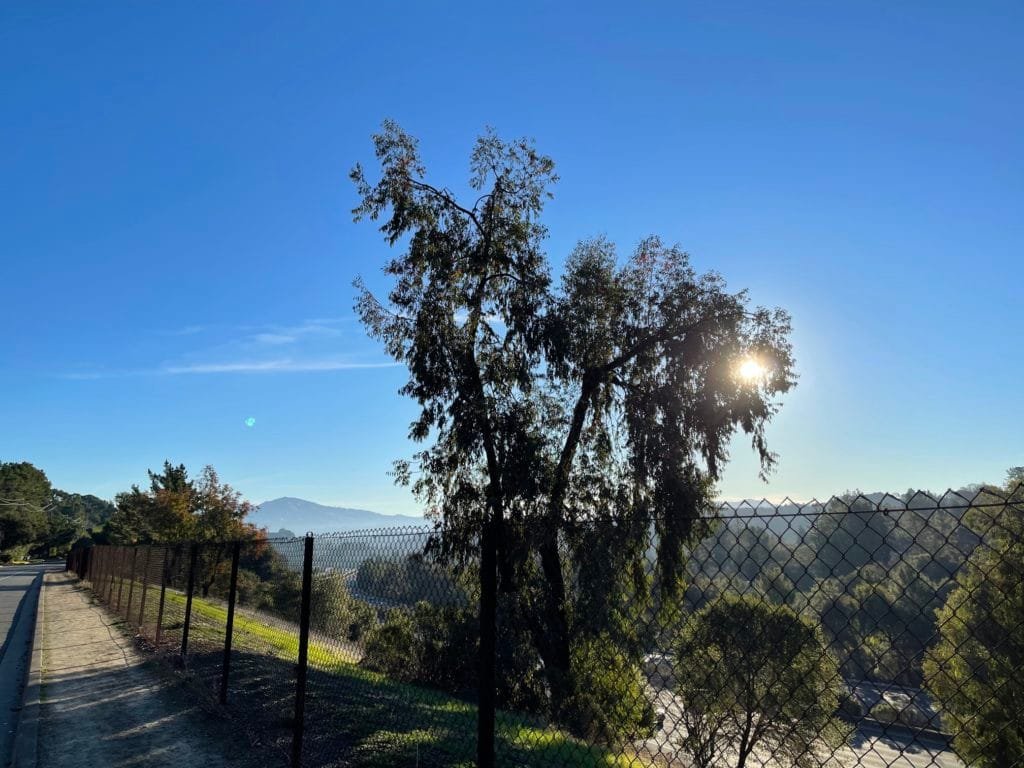
Then I had to go up and over the freeway to El Nido Ranch Road. A little climb along the road here, but I did get a nice view of Mt Diablo and the rising sun. I don’t usually stop and take pictures during my bike rides, but made an exception this time.
Then the trail crossed under the freeway and became Mt Diablo Blvd. As I peddled into downtown Lafayette, I set my eyes on a donut shop for a little break. Unfortunately, there was a big line in front of it, so I just drank a little Gatorade and headed back to the trail.
Fortunately (except for having to go over the freeway again), the trail moved to Deer Hill Rd to avoid the main part of the downtown area. Going through downtown probably wouldn’t be a big deal early on Saturday morning, but I stuck to the official trail and went over to Brown Rd where I (yet again) crossed under the freeway to get back to Mt Diablo Blvd.
I have to say, I thought this West-East part of the trail would be more level than it turned out to be. It wasn’t as big of a climb as the first part up Moraga Way, but it did have a good deal of ups and downs until I hit Pleasant Hill Rd and headed South.
At Olympic Blvd, the trail returns to a dedicated biking/hiking trail and I wouldn’t have to worry as much about cars except at crossings (unfortunately, this a part had a good deal of road crossings). It also marked the point that I had already biked up to from Moraga during my morning bike rides over the past month, so I had now covered the entire loop.
Just had to make it home now to finish the loop in one day. I didn’t really have much choice at that point, unless I called for an Uber. 🙂
Having done this part before, I knew I had a bunch of road crossings to navigate (although only one was a major road that had any traffic) and also some climbing to do as I headed South.
Past Rheem Rd the remaining section of trail was a nice coasting decent back to Moraga Commons Park where I started.
I just had to cross Moraga Rd quickly to finish the complete loop. I mentally patted my back as I celebrated and turned around to head home.
20 miles total for the morning in 2 hours. A pretty straight forward ride, but it was a nice accomplishment for the New Year and my new home town.
Go Pack!


Comments by WanderingJim
PCT or BUST!
"Yes, I’ll be going through there by early August"
JMT 2020 Day 3
"I'm afraid I have no idea. Not really a fisherman, so don't..."
JMT 2020 Trek Day by Day
"Yeah, but with 9,000 pictures, it's hard to label each one..."
Kilimanjaro – October 2019
"Everest Base camp is on my list too. Mostly since I know..."
Kilimanjaro
"You started hiking with Kilimanjaro first? Even I worked my..."