One of my ideas for Memorial Day weekend was to backpack the entire Ohlone Wilderness Trail over the long weekend. I had decided to cut my trip short last year and skipped climbing up to Mission Peak for the final night. I was also thinking of some other hikes, but once I decided to put this one into the mix the reservations for Maggies Half Ache Camp were not available for Saturday night.
Since I had been thinking of doing it over 3 nights this time to break up the long hike between Maggies and Eagle Springs near the top of Mission Peak, this kind of made the trek hard to schedule since I didn’t want to do Doe Camp again this year. Looking at the available campsites, I found that Maggies was available for Sunday night and several of the campsites in the Sunol Regional Park Backpacker Camp area were free the night before.
So, I decided to do the hike West to East instead of the way I’d done it the first and second time I did this trail. That did mean climbing up to Mission Peak on Friday afternoon.
The biggest problem would be if it was excessively hot for the weekend. You usually want to do this hike in late Fall or early Spring to avoid the oppressive heat Sunol and this area gets in the Summer. The weekend before had a mini-heatwave come through the Bay Area, which made me nervous for my chances to do this hike. Fortunately, the weather turned towards the cold side and it looked like it wouldn’t get too hot as the weekend went on.
Being a holiday weekend, I was able to get off work early and drive down to Dublin/Pleasanton BART Station. No where near the start point, but it did leave my Jeep in a location that I could get to relatively easily from the end point in Dell Valle Regional Park. I then took a train to the Warm Springs BART station. From that point, I took an Uber to the Mission Peak Trailhead.
A good deal of day hikers were on the trail as I started up with my huge backpack. It is always a bit hard to get my motor running early in a big multi-day hike, so I had to resist the urge to bail out as I started the 2,000 foot climb up to the back side of Mission Peak where the Eagle Spring Camp was. I could have gone up and over the actual peak to reach the camp, but that would add 200 extra feet of climbing with my full pack to the day’s hike. I’d go up later without the added weight.
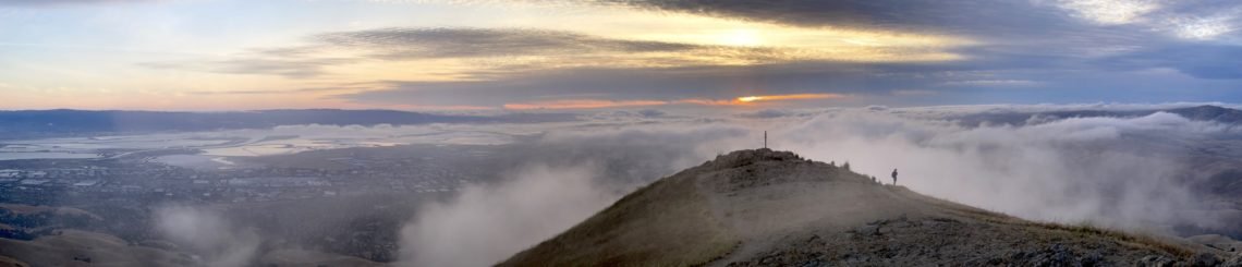
At camp, I setup my tent and finished my sub sandwich I had brought for dinner (I had the other half on the climb up from the trailhead). It had taken a bit longer to climb up than I expected (it almost always does, even if I pad my estimates with extra time), so I headed up to the top of Mission Peak to see the 180 degree views from the top and to catch the sunset from there.
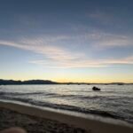
What a great view! You could see the entire South Bay and Silicon Valley to the west and the vast wilderness to the east that I would have to hike through. Although you could do this as a day hike, seeing the sunset or sunrise from the top usually was best done staying overnight at the camp.
As I waited for sunset, I took some pictures and checked out the summit marker. Oddly, it wasn’t at the actual summit (which I made sure to set foot on, of course). It was a hundred feet away and a bit lower than the actual summit. Not sure why that is.
It had some pipes attached to it as ‘viewfinders’. When you looked through them you could see various Bay Area landmarks, such as: Sutro Tower, Mt Diablo, and probably the Golden Gate Bridge. I didn’t have time to look through them all and there was fog in places that would have hidden some of them.
Some of that fog or low lying clouds started to roll over the top of the mountain before sunset, so some of the light was obscured at first. The remaining day trippers left when that happened, but since I was just staying nearby, I could wait out the clouds. It did open up a bit before the light disappeared, so was a pretty nice sight. I had forgotten to take a movie of the sunset that night, so no time lapse of that one.
I went to sleep, nice and dry.
I woke up to a wet tent (on the outside, fortunately). I had heard some water drops over the night, I’m not sure if there was some actual drizzle or it was just condensation from the cloudy skies all around me. It did mean there would be no sunrise to see, even from the peak. No reason to hurry to climb up to the top then. So, I had breakfast and enjoyed a little light from my campsite as the skies started to clear a bit.
Breaking camp, I had to resist the urge to abort back the west side of the mountain, but it wasn’t hard to continue towards the East. Fortunately, this part was all downhill in this direction (last year this would have a been a big uphill hike, which is what made me abort that trek early).
At Sunol Regional Park, I found out the little visitor’s center no longer had any soda or snacks available like they used to. Kind of disappointing not to get a little treat on my way through.
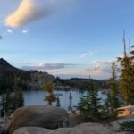
But at least that made me not spend a lot of time there and start my upward climb towards my camp for the night: Sky Camp. The backpacker campsites in Sunol are in a single general area, but widely spaced so you’re not right on top of other campers. I had originally wanted to try camping at Eagles Eyrie, but it wasn’t available. Sky Camp was, and it was probably better choice for me. Kind of out on a hillside by itself, it had some great views and should allow for some nice sunset and sunrise views.
It has an Upper and Lower site listed on my maps, so I could choose my location. The lower camp looked flatter, but would make me carry my gear down (and then up) maybe 150 feet. I decided the upper area was the better choice. I did have to contend with a lot of wind when setting up my tent, but fortunately I managed to get it up and secured with some spare para cord to the nearby tree to make sure it didn’t fly off.
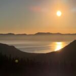
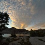
I found a nice spot about half ways between the upper and lower sites that had a good view to the west of the sunset. There were some clouds to the west that hid some of the sunset from me, but it was still a pretty nice way to end the 2nd day.
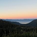
The morning brought a little more light from the sunrise than the first morning did, but it was mostly light piercing some of the clouds to light up the area around me. Still kind of nice.
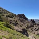
I had to resist aborting down to Sunol and getting an Uber back to my Jeep, but pressed forward. This should be the shortest day (about 6 miles), but it was about 2,000 more feet to climb to reach Maggies. I was glad I split this part into two parts this time.
The climb was slow going, but uneventful except for the views. A few annoying dips in the trail, but overall nothing too hard. My legs and feet disagree with that statement. 🙂
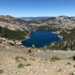
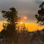
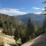
It was a fairly early arrival at Maggies, so I setup my tent without battling the wind this time. After doing my chores around camp, I headed to the top of Rose Peak (3,817 feet). This peak was just a little shorter than Mt Diablo, but was surrounded by hills and ridges so it doesn’t really stand out on the skyline. I’m sure not a lot of people in the Bay Area even know it’s there.
It did give a pretty good view of the area all the way to the Bay and you could see Mounts Tamalpais, Diablo, Hamilton, and Umunhum from there. After soaking in the peak, I checked where the sun would set and then rise. The sunrise would not be visible due to some trees and I had to find a spot a little down the west side of the peak that had an unobstructed view of the sunset. As a bonus, it would be setting right behind Mt Tamalpias.
This turned out to be the least cloudy of all three sunsets of this trip and was a great way to finish off the day.
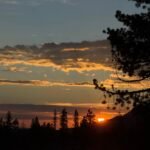
The next morning, I climbed the hill behind my campsite to a spot I had identified the previous day that would have a view of the sunrise. The lack of clouds kind of made the sunrise a bit bland, but still worth seeing.
There was no reason to think of aborting back to Sunol, since it was almost as far back that way as it was to complete the trek towards Dell Valle. It wasn’t completely downhill, but would be a lot easier and enjoyable than climbing up this trail from the east.
As I neared the end, I took advantage of a cell signal to try and get an Uber, Lyft, or Taxi to pick me up and get back to my Jeep. Unfortunately, I was not able to secure a ride by the time I reached the lake where the cell signal disappeared.
I celebrated my finishing the trek by… hiking 2.5 more miles. That was what I had to do to get to a spot along the road with a cell signal. It took me a little while there, but I did eventually secure an Uber ride. I made it back to my Jeep a little later than I would have liked, but I still got a well deserved pizza on the way home.
A nice long weekend and a good warmup to my big three week July trek.

Comments by WanderingJim
PCT DAY 85 – CA Section H
"No cell service in many parts of the PCT. Not dead yet."
PCT or BUST!
"Yes, I’ll be going through there by early August"
JMT 2020 Day 3
"I'm afraid I have no idea. Not really a fisherman, so don't..."
JMT 2020 Trek Day by Day
"Yeah, but with 9,000 pictures, it's hard to label each one..."
Kilimanjaro – October 2019
"Everest Base camp is on my list too. Mostly since I know..."