
Goal for the day: Anywhere along the ridge
After my success in finishing PCT section K over Labor Day weekend, I kept thinking of my failure to start section I from Sonora Pass in August. The longer section G hikes were not practical this late in the hiking season, but the shorter section of section I may still be possible now that my ankle felt better.
I’d have to go as light as possible like I did for section K, so only 4 nights of food. That that would prevent me from doubling back to exit via Sonora Pass or Kennedy Meadows. Since the first day and night along the ridge would be around 10,000 feet, I did have to swap my light sweatpants for my fleece pants to survive the colder nights. I also decided to start with only 1 liter of water (and my standard 20oz Gatorade bottle). I’d have to add some more water along the way. There was mention of an additional small trickle of water along the trail further up than the info in August indicated, so I took my chances and didn’t fill up lower on the climb up to the ridge.
The first part was a re-do of my August hike and the two small snowfields I had to cross then were almost completely melted off the trail. When I passed the spot where I had tweaked my ankle and had to turn back in August, I pushed forward towards the ridge that I hadn’t been able to reach the month before.

I was happy to find a small stream of snow melt water crossing the path near the top. I filled up my Camelbak to the full 3 liter capacity. Not having to carry 5 more pounds of water up from the Sonora Pass trailhead was a big win in my book.
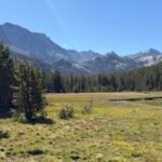
When I reached the ridge, I crossed over to the west side of the ridge line. For this section, that was a very good milestone. I could at least plan to spend one night somewhere along the ridge at that point. The hike along the ridge was mostly level, but still had the required small dips and re-climbs that sometimes suck the life out of hikers.


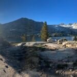
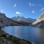
Unfortunately, I could see the darkening clouds moving in from the west that would be bringing the light rain that had been forecast. I passed a tarn fed by snow melt that had been the first possible water source on the ridge in August. It also had a flat area nearby to camp. But I had plenty of water and it was too early to camp.

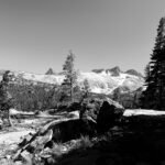
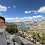
So, I continued along the ridge until I could see Leavitt Peak, the highest peak in the area. I hadn’t planned on climbing the extra 800 feet to the summit and seeing it in person reinforced that decision.

I was a little worried that I’d have to cross some of the snowfields that lay before me. The fact that I couldn’t see exactly where the PCT ran at first just added to my worries.
One thing that I found was a flow of melted snow water from one of the snow fields. That could have been useful info to have before I filled up on the climb to the ridge. I looked over the recent PCT reports and not one mentioned that possible water source.
There were three snow fields that I had to cross in this area. The first was small and easy to cross. The second one required a small detour along the bottom edge and them a small diagonal climb up the end of the snow field to continue along the PCT. So, a couple small diversions from the official PCT trail that was buried under that snow.
The third snow field was one I had seen a couple people climbing up and had hoped they were heading to the summit of Leavitt Peak so I didn’t have to climb that snow field.
No such luck.

The boot path up didn’t appear until I was pretty close. Snow and ice is sometimes hard to tell how slippery it will be until your boot hits it. While the climb up looked daunting, I managed to follow the previous boot prints and made it up without slipping or breaking through the snow. Fortunately, the people crossing had all kept on the same path instead of all trying to take their own path that could lead to a lot of broken up snow and bad spots to step on.
Remarkably, the boot path PERFECTLY followed the PCT trail on my map except for a small short cut near the bottom.

There had been some intermittent sprinkles up to that point, but it wasn’t until this point that the sprinkles turned to HAIL. Fortunately, it was small hail.
The hail and sprinkles continued off and on as I continued along the ridge line. At that point, I could stop at any point there was a flat area and consider the first day a success. The storm clouds filling the entire sky (except for a very small sliver of blue to the east that I would not be reaching that day) and the fact that the rain sprinkles weren’t heavy kind of kept me going. The clouds would kill the view of any sunset and there were few gaps in the ridge that would prevent having a possible sunrise view.


So, ironically, the weather encouraged me to keep going until I was nearing the point where some big switchbacks wound down from the ridge towards Kennedy Canyon.
I saw a group of pack mules descending from even higher up the ridge than I was. They were probably coming from Leavitt Lake on the east side of the ridge.


Reaching the end of the ridge line, I had to either find a place to camp or descend the switchbacks to camp down in the canyon.
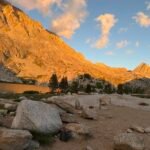
There weren’t a lot of obvious flat areas around. One had a very small windbreak that someone had built, but it would only fit a single person in a sleeping bag or small bivy. Just as I was preparing to descend on the switchbacks, I saw a rock outcropping near the trail which could provide some protection from the wind. Checking it out, I found several cleared spots for small tents and previous hikers had built up a bigger windscreen around the rock outcropping.
What finally sold me on staying on the ridge after all the bad weather that day was that the clouds had finally started to break and reveal the blue sky behind. A few beams of light settled the matter and I started setting up my tent. I had to use some rocks to anchor my tent to the ground and used some paracord to secure my tent to the windbreak to make sure it wasn’t going anywhere.

I re-hydrated my dinner and then walked to a high point to enjoy the spectacular sunset.


After all my failures this year, this was a very good start to my attempt to finish section I. Sweet dreams.

Total miles hiked: 8.5
Miles hiked one-way on PCT section I: 8.5
Goal: Successful and then some!!!


1 Pingback