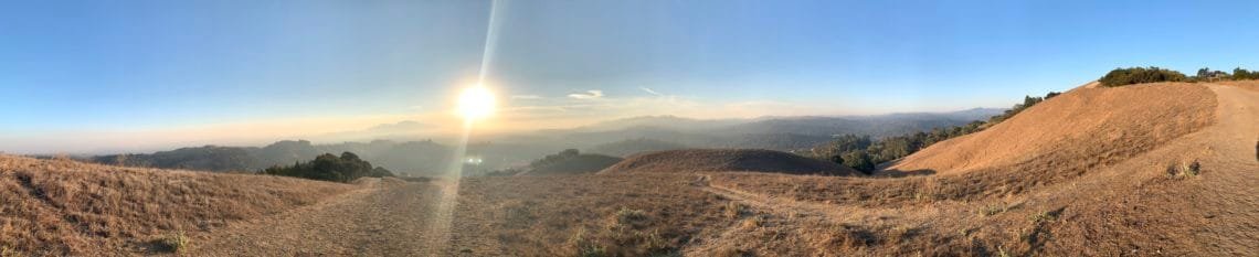
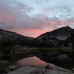
November started with a trip to Lafayette Ridge. The trail starts from the East and climbs up over a thousand feet, but also has some dips in the trail, so it’s a lot of up and down as you head towards Briones Regional Park along the ridge.
I took advantage of the earlier Sunrise due to the clocks falling back an hour and got some nice views of the Sun rising near Mt Diablo.
The views as I made my way along the long ridge were great and it was an enjoyable hike. I reached Russell Peak and took a break there.
Instead of retracing my path back to my Jeep, I decided to go along Briones ridge towards the Table Top Trail. From there, I descended via Blue Oak Trail.
I returned to my Jeep via Relize Valley Road. It was a short 8.5 miles altogether, but a nice change of pace to start November off.
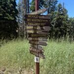
With my goal of hiking every trail in Mt Diablo State Park in 2020 still unfinished, I headed to the Regency Gate.
It was a very chilly day, but I’ve hiked in much colder so it wasn’t a problem. Just added a layer and wore gloves.
I started by going up Clayton Oaks Rd to Bruce Lee Spring Trail to knock out some small parts of trails that I had not been on this year yet.
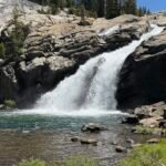
Then I went up Cardinet Oak Road to get to Falls Trail. Unfortunately, with no rain yet there weren’t any waterfalls to see along this trail.
When I got to Middle Trail, the plan was to head south and go up Old Prospectors Gap Road and then down the other side until it dead-ended at private property.
But my heart wasn’t in it. I just couldn’t get motivated to climb 1,500 feet, descend 900 feet, turn around, and re-climb that 900 feet at that point. Even if it would have finished my list of trails to hike, I just wasn’t feeling up to all that climbing this day. I should have trusted my initial thought when waking up that morning that I should do a simpler hike somewhere else.
So, I decided to return to the Regency Gate. But at least I did clear half of the Middle Trail and a part of Donner Canyon Road off my list.
The problem with skipping Old Prospectors Gap Road was that it was kind of right in the middle of the east side of the park without any direct trailheads nearby. So, it would be tough to get to that road to hike it.
I could drive into the park to Devils Elbow near the main summit and hike over on the North Peak Trail or possibly combine a hike up Mt Olympia and North Peak with it. I’d be a long day, but I’ve done similar hikes in the past. I could do it from Regency Gate as well, but that would be a pretty long hike… which was part of the reason I didn’t feel like doing it this particular day.
A couple hours after I finished my hike, a rain and thunder storm passed through the Bay Area. So even if it was a short rain shower, at least I avoided being caught in that.
Still 7 weekends left in 2020.
A quick morning hike up the Old Finey Road allowed me to finish off a small section of trail in that area. While the section was small (1/4 mile or so), I had to hike in a mile or so to reach it (partly due to there not being parking near the trailhead).
After completing the segment, I actually hiked up about a half mile further than I needed to. I felt good and wanted to get a little more exercise in while I was there.
I also checked out the new culvert they had been working on for the past few months. Nice and fresh looking. That will end as the weekend rains come. If the rains follow the forecast, I may be able to finish off Old Prospectors Gap Road this weekend and thus be able to finish off all the Mt Diablo trails in 2020.
And the next weekend… https://wandering.earth/index.php/2020/11/15/mt-diablo-state-park-2020-goal/
After finishing all the trails in Mt Diablo State Park, I decided I needed a change of scenery. I’d only managed to get to Mt Tamalpias once this year, so it was a natural choice.
I decided to start at Stinson Beach, but instead of going up the Matt Davis trail as I normally do when taking this route, I decided to try going up the Dipsea Trail. Often, this was the way I’d come down, so would be a little different.
After a little over a mile, I reached the Steep Ravine Trail but decided to continue southward on the Dipsea to Cardiac Hill.
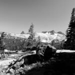
Fortunately, my heart was still beating when I reached that hill and took a brief rest. From there, it was a simple hike to the Pantoll junction via Old Mine Trail. From there I had my choices of routes to the East Peak.
I chose the easier route and went up the Old Stage Road to West Point Inn. After a break there, I went up the Old Railroad Grade Road before reaching the East Peak and enjoying the view.
It was probably one of the easier routes to take to get to the East Peak from Stinson Beach. I could have gone down via Middle Peak and Mountain Top trails or even out to Laurel Dell to get some variety, but I might not have made it down to my Jeep before sunset. I decided to go down Fern Creek Trail to West Point Inn and then to Pantoll.
I really wanted to return by the Matt Davis Trail, but when I weighed the 4.5 vs 3 mile return via Steep Ravine Trail, I decided to take the shorter route.
As it was, I made it back to my Jeep pretty close to sunset. I might have finished in the dark if I had gone down the Matt Davis Trail. Ah, the fun of late fall hiking. 🙂
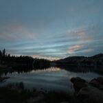
This did allow me to stop along Highway 1 and see the sunset over the Pacific. Gorgeous.
It also allowed me to see how my new iPhone handled sunset pictures. Quite well, in my humble opinion.
In order to start burning off the calories I’d be eating for Thanksgiving dinner, I spent that morning taking a long hike around Lime Ridge.
It’s near my home, so I do occasionally go out and hike the trials through the hills. I even got a chance to hike a few new trails this time.
It also reminded me that I don’t spend as much time hiking near my home as you’d think. Maybe I don’t go there that often because it doesn’t always feel like an adventure because it’s so close to the city or it’s hard to get away from it all when you’re overlooking the city.
In any case, it was a fun morning.
But it’d take more than a short hike to burn off all the turkey and pie I’d be eating for the next several nights (darn you leftovers 🙂 ).
To burn off more turkey calories, I decided to head out to Old Borges Ranch and hike some of the trails in Diablo Foothills Regional Park and Shell Ridge Open Space.
While I had hiked many of the trails in Diablo Foothills during my successful attempt to hike every trail in Mt Diablo State Park there were many in the southwest corner and the northern tip that I have never hiked before.
I didn’t have a set path in mind and was also thinking of hiking some of the trails in Shell Ridge as part of the day’s hiking. So when I started from the Borges Ranch trailhead, I could have gone to either area to start. I decided to head south towards the Foothills area.
I meandered around and then decided to go south on Hanging Valley Trail. From there, I could create a loop by leaving the Regional Park and going across Alamo Trail. Then I reentered the park on Foothills Trail. I decided to make sure I hiked all the trails in this part of the park, so I ended up going around in circles a few times. better to take care of them now than have to come back to catch any missed trails later.
It was an interesting part of the park with gently rolling hills, that fortunately weren’t too steep. By the time I finished these trails, I had cleared all the trails in the southern 2/3rds of the park during my 3 visits this year.
That did leave a short loop trial on the northern tip and the North Gate Trail, that loops up to the north gate of Mt Diablo State Park and then down again. I thought about doing these that day, but then decided that the 10 miles and 5 and a half hour hike I had already done was good enough for the day.
I could easily do those another day before the end of the year. While I did hike a few of the trails in Shell Ridge Open Space, there were a lot more. I decided I’d add doing all of those trails in 2021 to my list. 3-4 day hikes should be enough, but not this day.
That didn’t take long.
I usually don’t do two big hikes on the weekends, but I felt like hiking again on Sunday so headed back to Diablo Foothills Regional Park again.
The plan was to take care of the northern loop and the North Gate loop that I had never hiked before, plus a few small trails that I hadn’t hiked in 2020.
The North Gate loop was a pleasant hike. The only reason I had never hiked it before is the map has a big ‘Land Bank – No Access’ plastered on it. But if you look closely, they show the loop trail around the edges of the area with ‘trail open for use – stay on trail’. It’s also a little daunting because there’s a big hill in the middle that doesn’t encourage me to climb it. But the trail is around the sides of the hill, so it was a nice pleasant hike with only a little elevation gain.
The north loop was also a pleasant hike that I had never hiked because it doesn’t really go anywhere. Just loops around the northern tip of the park’s boundaries.
From there, it was just a few small trails that I had to hike to clear hiking all the trails in the entire park for the year. Goal! (although I didn’t really intend this as a goal until this week when I was looking for someplace to hike this weekend 🙂 )
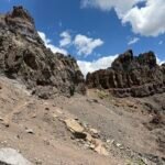
I also ended up going down to the trails that climbed up to the large rock formations in the Castle Rock area. Mostly just hiking and climbing until these use trails ended or got too difficult for me to climb further.
So, another 9 miles and 4 hours of hiking this weekend. Better than sitting at home watching football (Packers are playing on Sunday night, anyways 🙂 ).


Comments by WanderingJim
PCT DAY 85 – CA Section H
"No cell service in many parts of the PCT. Not dead yet."
PCT or BUST!
"Yes, I’ll be going through there by early August"
JMT 2020 Day 3
"I'm afraid I have no idea. Not really a fisherman, so don't..."
JMT 2020 Trek Day by Day
"Yeah, but with 9,000 pictures, it's hard to label each one..."
Kilimanjaro – October 2019
"Everest Base camp is on my list too. Mostly since I know..."