You’d think after 266 miles in 25 days, I’d be sick of hiking and the wilderness for the year…
Nope!
What I was sick of was being at home, hiking the same areas in the Bay Area over and over, and not being able to fully enjoy the mountains.
But this year has had a lot of challenges that would make a Fall trip to the mountains harder than normal:
- COVID-19 limited where and when I could hike.
- The fires all over California also reduced where I could go and where I would want to go.
- The fast approaching Winter would also further limit me (since I wanted to get to the mountains before the snow came).
- And finally, a lot of forests and parks were closed due to some or all of the above reasons.
Going through my options, I decided on a climb of White Mountain Peak east of Bishop because:
- The area was open.
- I could go there and return within a weekend.
- Based on reports, the smoke from the fires wouldn’t completely ruin the view and my ability to breathe.
- I would enjoy the hike.
- It would be a nice change of pace for this year.
While I had climbed this peak once before (and failed to reach the peak once before that), it was a nice enjoyable hike that was nearby.
Without COVID-19 and the smoke hampering my choices I would have a wider range of options, but I decided this was my best choice.
The primary way to access this peak was to drive from Bishop, up through the Ancient Bristlecone Pine Forest on a 10 mile paved road, followed by another 10 miles of dirt and rocks. I had slashed a tire two years ago on that road, but they obviously did some repairs and the prior year was much better.
After the drive, you hit a locked gate that leads to the summit and also the University of California’s Barcroft Research Station. The Barcroft Gate is where you either park for day hikes or camp for a night before heading to to summit the next morning. Since White Mountain Peak is 14,252 feet high, it also serves as a good place to acclimatize. The gate was at about 11,700 feet. Like I had done the year before, it also is a good place to acclimatize before climbing some of the high mountains in the Sierra Nevada Mountains.
I had thought about possibly bringing my backpacking gear and hiking into the wilderness part of the way and camping overnight. This would allow me to get a different view of the sunset than you could see from the trailhead. It would also allow for an earlier attempt at the summit and thus a earlier return from the mountain.
In the end, I didn’t feel like putting together all my gear for a single night of backpacking and I still had a few peices of gear that I needed to replace from my JMT trek.
So like I had for the previous two years, I decided to just drive to the gate and stay overnight there.
The drive was long, but I did get a chance to see some nice fall color along the way. The eastern side of the Sierras always seems to have more color in the Fall than the west side. But maybe that’s just where I happen to have visited in the Fall.
I filled up my gas tank on the way through Bishop and picked up a foot long sub sandwich for dinner (so I didn’t have to heat up anything).
The drive from there was a steep winding road through the mountains toward Westgard Pass, but before hitting that pass you turn north onto White Mountain Peak Road.
The paved road that winds north through the mountains is very scenic and an enjoyable drive. Then you pass Schulman Grove and-as mentioned above-the pavement ends.
The dirt road wasn’t that bad, but does require you to pay attention for any sharp rocks that may destroy your tires. Fortunately, I had no problems this year with the road that a car wash wouldn’t solve after my trip.
At the gate, I found a level area to park. I could have put up a tent and slept in that, but decided to just put my back seats down and sleep in the back of my Jeep.
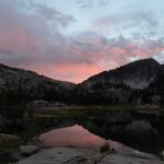
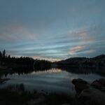
Before that, I just hung out around the area and took in some of the sights. While the mountain ridge I was on was clear of smoke, there was a very thick layer of smoke covering the area around Bishop. From below, it made it very hard to see any of the surrounding mountains.
From above, it seemed to be hugging the floor of the Owens Valley as far as you could see.
Unfortunately, the thick band of smoke to the west meant that the sunset would be about 2 hours early. The late afternoon sun did cast some nice patterns of light through the smoke and across the surrounding mountains, but it wasn’t as spectacular as the previous times I had been up in that area overnight.
I ate my sandwich and then settled into my sleeping bag to read a book and watch some videos before falling asleep around 9am.
My plan was to get up well before sunrise (which would be around 7am) and head up the trail towards the summit. I could enjoy the light from the sunrise along the way, depending on my progress.
The first time I attempted to climb White Mountain Peak, I had made it about 5 miles and ran out of steam before the final climb to the summit.
The second time, I successfully reached the summit.
This time… I almost gave up after only hiking a half mile and climbing a mere 400 feet. I felt very fatigued and started to get a headache along with feeling some slight numbness in my fingers.
I knew I was rushing any kind of acclimatization with only spending one night at altitude at the gate and taking small doses of Diamox for 4 days, but the speed of these symptoms surprised me.
I took a break and ate some more of my breakfast (some donuts and bacon jerky) and got a kick of caffeine with a can of Diet Coke (that I had hoped to save for the summit). I also took a couple of Advil tablets. Since the trail from that point was a little more level until you passed the Barcroft research station, I pushed myself to go a little further after a couple of way-too-long breaks. It was probably over an hour altogether.
As I neared the station, I paused to enjoy the sunrise over the eastern sky. There was very low band of smoke to the east, but fortunately it wasn’t enough to totally hide the beauty of the rising sun and it’s effects over the surrounding area.
I don’t know if the sunrise re-energized me or the additional breakfast, Diet Coke, or Advil helped me, but I was feeling much better by that point and decided to press on towards the summit.
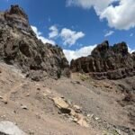
After the station, there are a small set of switchbacks leading up to a small observatory near Barcroft Mountain. Since these switchbacks were about the last place to easily see the sunrise along the trail for the next couple of miles, maybe the long delay caused by by how bad I felt after starting the hike may have helped keep me in position to see that beautiful sunrise. But I probably would have made an effort to find a good spot to see it regardless of where I was at sunrise. It just might have required hiking east from the trail a bit.
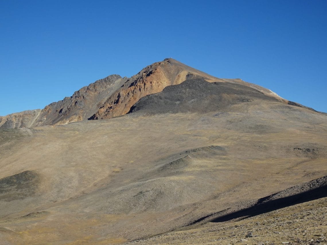
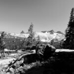
After passing the observatory and weather equipment, there was a long hike along the ridge towards the peak. This was the easier part of the hike, but was still a long stretch. Then you reach the point before you have to descend down along the saddle that connected the ridge to the main peak. That’s where you get your first real view of the many long switchbacks that wind up the side of the peak.
This was the view that caused me to abort my first attempt at climbing this mountain. The combination of seeing the dip in the trail (a mere 200-300 feet, but still seemed daunting after 5 miles) and the endless switchbacks were too much for me two years prior.
So like I did the year before, I didn’t spend any time contemplating that view and just started the final hike towards the summit.
The ‘dip’ in the trail over the saddle was not a problem and was mostly a mental challenge to avoid getting discouraged by it.
The switchbacks were a more real obstacle and took a lot of time to ascend.
Not too far from the bottom of the switchbacks, I heard a rumbling. Rockslide? Thunder? Thor’s hammer?
Nope.
Three bighorn sheep were scrambling down the mountainside.
It seemed they were spooked by some other hikers. The sheep were also cutting the switchbacks! The jerks! 🙂
It was an interesting sight and I think it might be the only time I’ve seen bighorn sheep in the wild (at least I thing they were bighorn sheep, I’m not an expert).
Then it was back to climbing towards the summit. The prior year there had been a big snow field before the summit, so you had to detour around it. I planned on following the entire trail to the northern turn this time, but as I was making the turn back to the summit, I realized that I had followed a very well traveled shortcut that looked like the real trail.
At that point, it was too late to change my route so I finished the last few smaller switchbacks and reached the summit.
Goal!
The summit had a little stone hut, much like Mt Whitney’s Survey Hut. It was used for weather observations and experiments by the Barcroft research station.
I patted myself on the back for making it all the way, despite my feeling so horrible at the start of the hike.
Fortunately, the area around the summit and the skies to the east were mostly clear of smoke or haze. The western sky was pretty hazy, but you could see the tops of the mountains across Owens Valley. But you couldn’t see much of anything down in the valley.
I took my usual series of pictures of my feet at the summit, many panoramic shots of the area, and some selfies to prove I was there. I did have a moment when my iPhone had some problems with the camera, but I got it working and I had my Sony camera as well. Maybe my iPhone knew I was replacing it soon with a new iPhone 12 Pro Max. 🙂
One odd thing I don’t recall seeing on my previous trip to the summit was a stainless steel dog bowl that was cemented into the mountain side just under the summit. It wasn’t anywhere that you’d put a bowl for an actual dog to drink from, so I assumed it was a memorial to someone or somedog.
Then it was time to descend and return to the real world. Maybe I should just become a hermit that lives at the top of a mountain. 🙂
On the way down, I made a point of going all the way to the real northern corner of the trail. It’s actually much easier to use that trail than the steeper shortcut that tricked me on the way up.
Going down the switchbacks was still long and hard, but once they were done, you just had a the small section after the saddle and the climb up to the observatory to climb.
It should have been easy from that point…
I’m still not sure how, but I slipped on some loose rocks along the trail and twisted my ankle. Either I was tired or not paying enough attention on the way down. Or both. Either way, it hurt pretty badly.
I continued back to the trailhead, but I didn’t make it far until the pain forced me to stop and take my boot off to see what it looked like.
The good news was it didn’t look broken and wasn’t swelling up. The bad news was there was some bruising.
Fortunately, I do always carry some sport tape in my day pack. I wraped up my ankle to give it a little more support, put my socks and boots on, and slowly continued south.
I was slow going, but I found a way of walking with my trekking poles that kept the pain to a minimum. A couple ibuprofen tablets also helped.
I had thought I may have to knock on the door of the research station to get a drive back to my Jeep, but when I got there I noticed there were no cars or trucks around and all the windows and doors were boarded up. They were obviously shut down for the Winter.
Since I was able to walk somewhat, I didn’t see the need to call 911 for help or ask to be carried by other hikers (but I did think about asking for the later a few times 🙂 ). If it was much further to hike or more of a uphill climb, I might have needed help.
So it took a lot longer coming down that it should have, but I did make it back to my Jeep. Fortunately, it was my left ankle, so I could still drive with my right foot.
So a little over 14 miles round trip. But with the long breaks at the start of the hike and the slow descent due to my tweaked ankle, it took me almost 12 hours to go up and down. Compare that to 9 hours that it took me the previous year.
So, I didn’t set any speed records, but I made it to the summit and back down. I didn’t get back to the Bay Area until after midnight.
Even with the problems, I feel it was worth it to get to the mountains one last time (probably) this year. And fortunately, my ankle got better after a few days.
Enjoy the pictures and a time lapse movie of the sunrise below.


Comments by WanderingJim
PCT DAY 85 – CA Section H
"No cell service in many parts of the PCT. Not dead yet."
PCT or BUST!
"Yes, I’ll be going through there by early August"
JMT 2020 Day 3
"I'm afraid I have no idea. Not really a fisherman, so don't..."
JMT 2020 Trek Day by Day
"Yeah, but with 9,000 pictures, it's hard to label each one..."
Kilimanjaro – October 2019
"Everest Base camp is on my list too. Mostly since I know..."