The second Saturday in June I had thought to go to Black Diamond Mines Regional Park since I hadn’t gone the weekend before.
Instead, I decided to go to a closer trail that I hadn’t done before: Pinole Ridge. It’s an East Bay MUD location, so my permit came in handy once again.
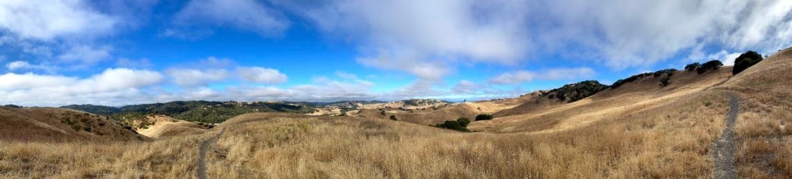
It’s actually a little to the north of Briones Regional Park and I had unknowingly driven by the trailhead many times. I decided to do a big look that covered the entire ridge line and then looped back through some old cattle grazing areas.
Under gray skies, I started up and headed towards the high point of the trail: Pinole Peak. Why start with the high point? Well, it was cooler in the morning and should be a better direction to do considering it would heat up as I hiked into the afternoon. This area had some open views of the Delta, so would get some cool breezes from that direction (which is one of hte reasons I choose this hike over the very much hotter area around Black Diamond Mines).
Although it was a lot to climb at the start of the day, only the last 100-200 feet were really steep. Reaching Pinole Peak (1,040 feet), I surveyed the area around me and then found a rock in the shade to take a break on. I would saver that shade, since it looked like a lot of the trail didn’t have much tree cover.
Continuing along the trail that followed the undulating hills a little too well, so I had a lot of ups and downs for a while. Reaching a more level area with a downward slant, I took a long break at a picnic table. Unfortunately, it was in full sun.
From there, there was a steep decent towards a housing development, followed by a gradual climb before my first decision point. It was a trail that would cut about 3 miles off the loop. Tempting, but I decided to continue to do the full loop I had planned to do. Since this was the first time doing this trail, I wanted to see as much of it as possible.
I was rewarded with some great views of Mt Diablo and Mt Tamalpias. As usual, I had second thoughts about choosing the longer route about half way to the far end of the loop. Too late to do anything about it, of course. 🙂
At this point, I had to walk along Alhambra Valley Road to what I thought was a connecting trail to take me to the trail back to the trailhead.
Unfortunately, it turned out to be a fire road that was closed to hiking. That was one of the drawbacks of EBMUD trails: Sometimes they closed off various side roads and fire roads to hikers, even if they would help connect to other trails or were in good condition otherwise.
So, I continued down the road, keeping to the left side since it allowed me time to react to oncoming traffic. So the last 3 miles of my 9 mile loop ended up being along the road before got to my Jeep and cranked the air conditioner up and drank a Diet Coke.
Not a bad pre-birthday hike for me.


Comments by WanderingJim
PCT or BUST!
"Yes, I’ll be going through there by early August"
JMT 2020 Day 3
"I'm afraid I have no idea. Not really a fisherman, so don't..."
JMT 2020 Trek Day by Day
"Yeah, but with 9,000 pictures, it's hard to label each one..."
Kilimanjaro – October 2019
"Everest Base camp is on my list too. Mostly since I know..."
Kilimanjaro
"You started hiking with Kilimanjaro first? Even I worked my..."