After my pre-birthday hike at Pinole Ridge the previous weekend that gave me a chance to hike in a new area, I decided to do a familiar hike from Stinson Beach to the East Peak of Mt Tamalpais, but with a twist.
I had decided not to do a big hike on my birthday for two reasons: I didn’t want to take a day off work and the Bay Area (and much of the West) was having an incredible Heat wave that was baking the area. Even being near the coast, it would have been harsh to do a big hike during the height of the Heat Wave.
Things were supposed to cool off for the weekend, but not enough to do a big hike in the East Bay even if the temperatures may be a little lower than the 100+ degrees we had experienced the previous 3 days.
So I headed for the coast and parked at the Matt Davis Trailhead in downtown Stinson Beach and headed up the trail through the lush ferns and trees surrounding the town. I had done this route many times before, but decided that instead of ascending to Rock Springs and going across the top of the ridge line connecting the West, Middle, and East Peak, I’d go all the way to the Pan Toll Ranger Station, and go up Old Railroad Grade Road.
It was a little longer than the other route, but a little less steep. I usually use that as a descent route more often than acceding using it.
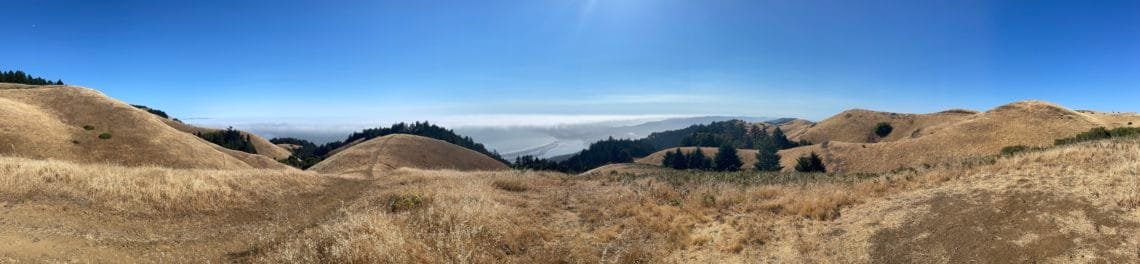
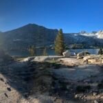
On the way up, I was glad that the ocean fog was rolling in across the ridge line to the south of Mt Tamalpais. Then I kind of wished it was covering the mountain, since it was starting to heat up pretty quickly as I climbed up.
The first part of the Matt Davis Trail had a decent amount of tree cover, but then was in direct sunlight as I made my way across to Pan Toll. The Old Railroad Grade was almost all exposed during the climb to the East Peak. Looking at a temperature map, it seems that Mt Tam was basically the dividing live between the cooler temps southwRD down the coast and the higher temps in the North Bay.
Ah well… onward and upward. Four and a half hours to the peak in about 8.5 miles, pretty decent time for me. After finding a shaded spot to have a short lunch, I had to start down again.
My original idea was to go down the Northside Trail to Laurel Dell, then down to Stinson Beach via Wilson Camp Fire Road. I had been down to Laurel Bell once before, but as part of a loop from Rock Springs. Using Wilson Camp Fire Road would be a nice new way to end a big loop down to the beach.
Unfortunately, my GPS app showed that route was going to be about 9 miles. Add that to the up route, that would be a very long day. Maybe I should have used the shorter route on the way up after all. For the first couple of miles of the downward hike, I thought about switching and just using that short route to return to my Jeep even after it became harder to switch to the shorter route than it would be be worth.
Fortunately, the north side of Mt Tam’s ridge sheltered me from the sun and had a decent amount of tree cover, so it helped keep the heat from baking me worse than it had on the way up.
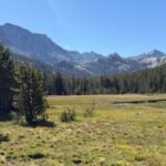
I also took the Lower Northside and High Marsh Trails to see some new parts of the north side that I hadn’t seen before. Unfortunately, it was mostly forest, so not much to see except for a few peeks at the rolling hills and ridges to the north. They were already pretty brown due to the lack of rain the previous winter. Mt Tam and the area to the south was still mostly green due to the wetter coastal environment.
Reaching Bare Knoll, I enjoyed the view all around me. I was a little distressed to see the ridge that Ridgecrest Blvd ran across was about at the same level as I was at, but was separated from me by a deep gorge. Meaning I’d have to go down and the hike up again to reach it, which I had to do to reach the Willow Camp Fire Road.
Although I originally had thought about going down past Cataract Falls, I decided to skip that since it would be dry now and took a slightly shorter trail down past Laurel Dell before starting to climb up towards the road.
At the road, I thought about hitch hiking down to Pan Toll or even getting a Uber or Lyft to avoid the 2 mile hike down to the sea level. 2 miles isn’t a big deal, except at the end of a very LONG day and when you have to descend about 1,900 feet making it a pretty steep descent.
There was still the option of hiking down the Coastal Trail and using the Matt Davis Trail. It would be less steep, but almost 2 miles longer. Since I had misjudged how much water I had when I had a chance to refill my Camelbak at the East Peak, I was now down to maybe 10 ounces of Gatorade. So, I really needed to take the shorter one in order to get down to the town to buy a Diet Coke to chug down to quench my thirst.
I was pretty much in full sun all the way down, thankfully I was helped by a cool breeze blowing in from the Ocean. But I have to admit the views for this route were very nice due to all the open space allowing me to see far up and down the coast.
Stepping off the dirt trail onto pavement was a nice feeling until I found that I still had a half mile and 400 feet to descend to get to the Diet coke, dinner, and the beach.
Unfortunately, the market was closed by the time I reached it, so no Diet Coke. But the little cafe near the beach allowed me to get some Fish and Chips and a Strawberry Shake. I walked that last couple blocks to the beach in order to finish a very long loop from sea level to 2,572 feet and back to sea level. While I had done some hikes that were the equivalent elevation gain of going from sea level to the summit (such as my Kilimanjaro trek), this was my routine ‘sea level to summit’ hike that I had done many times before.
Never this long before.
It ended up being 10 and a half miles down from the summit to the beach. An extra mile and half over what my GPS said it would be when I started down.
So 19 miles in about 11 hours. Not my longest day hike, but an impressive day on the trail. I was happy to see some new parts of that area.
Not doing a big bike ride the next day, though. 🙂
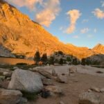
I did get to see some light from the setting sun at the beach before it vanished behind some low clouds along the coast. I drove up the Panoramic Highway trying to get above the clouds and got some more light at a couple spots, but by the time I reached the ridge line extending south from Mt Tam it was pretty much socked in all the way back to Highway 1.


Comments by WanderingJim
PCT or BUST!
"Yes, I’ll be going through there by early August"
JMT 2020 Day 3
"I'm afraid I have no idea. Not really a fisherman, so don't..."
JMT 2020 Trek Day by Day
"Yeah, but with 9,000 pictures, it's hard to label each one..."
Kilimanjaro – October 2019
"Everest Base camp is on my list too. Mostly since I know..."
Kilimanjaro
"You started hiking with Kilimanjaro first? Even I worked my..."