Best laid plans…
So, for my big Yosemite trip I had decided to explore the high country north of the Tioga Road. This is an area of Yosemite I hadn’t had much chance to explore outside of the areas immediately around Hetch Hetchy, Ten Lakes, and the Grand Canyon of the Tuolumne River.
Since you have to apply for wilderness permits 170 days ahead of the date you start, I had a couple of different plans I could use if I started from Tuolumne Meadows or Murphy Creek. I ended up getting a Murphy Creek permit.
From there, I could go up to Glen Aulin and then either follow the PCT up Cold Canyon or go down into the Grand Canyon of the Tuolumne River. As July approached, I decided the low snowfall causing waterfalls to not be running as strong as I’d like and the low altitude of the canyon that would cause high temperatures made following the PCT the better choice.
Starting off the day before the Fourth of July, I started up Murphy Creek. Unfortunately, it was a rough way to start a trek with a fairly strenuous climb up and then down towards Glen Aulin. It was a pleasant enough hike otherwise, but I was pretty tired by the time I reached Glen Aulin.
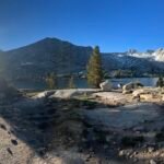
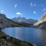
After enjoying seeing the White Cascade, I looked around the Glen Aulin backpackers camp for a good site. But I generally try to avoid camping in crowded areas when backpacking, so even being pretty tired after the day’s nearly 8 mile hike to that point, I decided to continue up Cold Canyon at least for another mile or two to see if I could find a good spot. I filled up on water since I wasn’t sure what the water situation was going to be like up in the canyon.
Naturally, I passed a small pond not soon after that could have saved me carrying some of the water weight up from Glen Aulin. Regardless, it wasn’t soon after that when I saw an open area along the cliffs surrounding a creak running through the canyon.
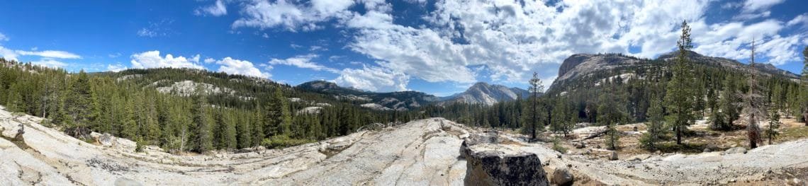
I took a quick look around and it seemed like a good camping spot. Some nice flat areas to setup my tent, some wide views of the area all the way down to the cliffs and domes surrounding Glen Aulin, and just a short hop back to the pond if I needed any more water.
The skies were a bit overcast, so I setup my tent on a clear area with a wide view of the area. Not much shade at that spot, but with the cloud cover, it shouldn’t be a problem if I had to slip into my tent to let my legs rest or to escape the mosquitoes. Fortunately, the later didn’t seem to much of a problem there. They had been pretty bad coming up Murphy Creek and in Glen Aulin, to the point I was a bit worried at how much insect repellent I had already used on day 1 of this trek.
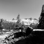
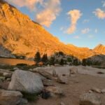
After dinner, I enjoyed the light from the sunset. The clouds did block some of the light, but they also caused some nice patterns of color in the skies.
I used my new camera setup to capture some of the light. For many years, I had been using my iPhone to capture time lapse movies of the sunsets and sunrises and using my compact camera to take other pictures of the sunsets. While that made some sense when using my old iPhone XR, my iPhone 12 Pro Max had very impressive cameras that may be better used to collect photos and panoramas of the sunsets and sunrises during my treks.
So I decided to pull out my old Sony HX-90V camera to handle the recording of the movies of the sunsets and sunrises that I encountered on my treks. It had a cracked LCD screen, but I could still use it to record movies and take pictures. The LCD worked well enough to see the basic framing of the picture and some of the status information. Plus, the pop-up viewfinder could also be used to confirm I was getting a good video. I had ordered a $20 LCD replacement, but it didn’t come in time for this trip.
And finally, to replace my broken Sony HX99 and the Panasonic DC-ZS200 camera I had tested for a couple months earlier in the year before returning it since it was too big and didn’t quite take pictures to my satifaction, I decided to get a Sony ZV1.
This camera has a 1 inch sensor like the RX100 v7 I had tried last year had, but I had found it too hard to get the pictures I wanted since the RX100 camera was geared towards professional photographers. The ZV1 was targeted more at VBloggers, which I am NOT one of. But it looked like the controls and specs would be more suited for me to use than the RX100.
The ZV1 only had 2.9x optical zoom, so would be quite different than the 30x optical zoom the XH90V and HX99 have. But since I didn’t use the zoom a lot, I decided to give it a try. Since I was bringing the HX90V, I could always use the 30x zoom on that camera if I really needed to zoom in on something.
It had no pop-up viewfinder, but I rarely used that anyway. The lack of a built-in flash might also cause issues, but since I mostly would use it to take landscape and other pictures during my treks, it shouldn’t be a huge loss for me.
So, I went from carrying two cameras (my iPhone and whatever compact camera I had), to carrying 3 cameras. While the extra camera wasn’t large or heavy, every extra ounce matters when backpacking.
My initial sunset pictures showed promise and after dark, I also tried out the 30-second long shutter capabilities and was quite impressed in how well it took pictures of the vast starry skies I encounter during my treks. My HX99 took decent star pictures, but the ZV1 was clearly better and even showed the details of the Milky Way way better than my older cameras ever did (except for the RX100). Some of them tended to have a green tint, but not all of them so I hoped it was just the particular hew of the sky at those times. I had more time to test the camera before I decided if I will keep it.
The next morning I ate breakfast as I waited for the sunrise. Again, the light didn’t disappoint. While the actual Sun took its time to rise above the ridge line to the east of my campsite, the glow from the sun lit up the domes and surrounding cliff sides nicely. A nice start to day 2.
After packing up my gear, I took a quick hop back to the pond to fill up on water. Since I wasn’t sure of the availability of water up the canyon, I maxed out my Camelbak and Gatorade bottle. I didn’t like the extra weight, but the maps didn’t show any guaranteed water until the McCabe Lakes or Virginia Canyon, both of which were 7+ miles up the canyon.
Naturally, after an hour or so, there was a small running stream that ran alongside the trail for a bit. Figures. 🙂
At the junction to McCabe Lakes, I had to decide if I wanted to take the 2 mile detour to the lakes to spend the night there, or continue along the PCT to get to Miller Lake (or at least as far as my legs would carry me that day). The 800 foot climb to the lakes and extra 4 miles (round trip) made me decide to just continue along the PCT.
I took a break once I descended down into Virginia Canyon along Return Creek (more of a river at that point). A couple creek crossings were a but tricky, but I got across with only one damp foot.
From there, it would be a steep climb up towards Miller Lake. Being mid-afternoon already, I was doubtful I would be able to make it all the way to Miller Lake at that point. Maybe I should have taken the detour to McCabe Lakes after all.
Regardless, I pressed on and decided to stop before I had to go up a steep set of switchbacks. It’s always easier to deal with switchbacks on fresh legs.
I found an area that had some open views of the south and tried to locate a flat surface to set up my tent. I found a couple, but they didn’t have any shade. I felt that I’d need to lay down to rest my legs by that point, so I kept looking until I found an area that should fit the bill. Not much of a view, but I could always walk a few dozen feet to see the view that was there.
I setup my tent and lay down for some much needed rest.
Unfortunately, the Sun has this nasty habit of moving (okay, it’s actually the Earth that’s moving, but you know what I mean). Sadly, the tent started to get baked in the Sun as the afternoon went on. I had to brave the mosquitos to avoid the heat, but fortunately they weren’t too bad.
As I waited for sunset, I did some exploring and did finally find a place for my tent with a view AND some shade that should last the rest of the afternoon. I don’t like moving my tent after setting it up, but in this case I felt it was worth it.
I had dinner and then enjoyed the sunset. While the view wasn’t as great as the previous night, it was still a nice end to a very tiring day.
I went to bad with doubts about being able to continue along the PCT the next day. Those doubts were still forefront in my mind the next morning as I had breakfast and watched the sunrise.
The problem with continuing is the next abort routes would be at least two days ahead of me and would likely be a 3 day abort at that point. I had plenty of food to continue, but the past two days had taken more out of me that I thought they would have. The heat was a bit more that you’d expect in the higher parts of Yosemite and I just wasn’t feeling like I had a good chance of making it all the way to Tilden and Wilma lakes where I had planned to turn south towards Hetch Hetchy.
This trek wasn’t anywhere near as challenging as doing the entire JMT last year, but also suffered from not having a particular ‘goal’ in mind. On the JMT I was able to push myself forward a few times with the thought that I had the big goal of doing the entire JMT ahead of me.
This time, I didn’t have that big goal to motivate me. I tried to continue, but somehow knowing the switchbacks awaited me sapped my desire to continue.
Reluctantly, I decided to turn around and abort back to the Murphy Creek trailhead at Tenaya Lake. Having to go back the same trail wasn’t that enjoyable, but I just couldn’t push myself to continue north on the PCT.
I had briefly rested at the junction to the McCabe Lakes to see if I could convince myself to climb up to them and spend the night there. It would be a short day, but maybe it would reinvigorate me enough to turn around and try to continue my trek the next morning.
Alas, my sore and tired body won the argument and I continued south back to my starting point.
I did take a break at a pool fed by the creek near the trail to take a quick dip to cool off and get the first layer of dirt off my body. That was a nice break.
Unfortunately, it didn’t make me want to turn around and continue back up the PCT. At that point I was too far into the abort that it made changing my mind almost impossible.
I had thought about going all the way to Glen Aulin and camp there or even further down Murphy Creek to a spot I had identified on the way up as a possible good place to camp, but the extra mileage at that point didn’t seem like a good idea.
So, while I normally hate to camp at the same locations during my back country treks, in this case it was the best choice to avoid the crowds at the backpackers camp or the extra mileage that I would need to hike to reach the spot along Murphy Creek.
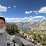
The skies were very clear this time, so I chose an area shaded by trees to setup my camp. It was further back from the grand view I had enjoyed on night 1, but would give me a cool spot to lay down and rest. I could easily walk out to the rock outcropping that allowed me to see the great view for sunset and sunrise.
Can’t fault the quality of the sunset or sunrise from there, but it was marred by my knowing that I had failed on this particular trek.
Since I had the whole week off and my wilderness permit was still valid for that week, I tried to come up with some alternate hikes I could do to make something out of this trip.
I could go down towards Waterwheel Falls the next morning and hike through the Grand Canyon of the Tuolumne River. That would be a nice hike, but the 4000 foot descent and climb, plus the high heat of the lower part of the canyon did not encourage me at all to take that route.
I also could detour to May Lake (and maybe even climb Mt Hoffman) or even Ten Lakes. I even looked at a route that could take me to May Lake, down over Tioga Road, and all the way to Clouds Rest. I’d have to decide in the morning.
After breakfast and watching the sunrise, I packed my gear and continued back down the trail.
It was easy to not decide to go down through the Grand Canyon of the Tuolumne River. I had no energy to try that route.
Reaching the trail to May Lake and Ten Lakes, I just couldn’t find the motivation or energy to extend the trek even by a single day. Clouds Rest would be out of the question too.
I did confirm that the area I thought would be a good camping spot would, in fact, be a great spot to camp.
But at that point I was resigned to my failure and was craving a real meal and a Diet Coke.
I did run out of water about a mile and a half away from the trailhead and there wasn’t any running water along the final part of the trail. Maybe a half mile from the trailhead, there were some small pools of water in the creek’s dried up contours. But I decided to not bother with stopping to filter that stale water and just push for the trailhead.
Reaching my Jeep, I took a bottle of water from it and poured it over my head to cool down. Then I grabbed a spare bottle of Gatorade I kept in my Jeep and chugged half of it down in one go.
Disappointed at my failure, I took off my hiking boots and put on a clean T-shirt. Then I headed down to the Tuolumne Meadows Grill and Store to get that Diet Coke and hot meal.
I did get a cheeseburger, but then I found that they were completely cleaned out of any soda products. So like my JMT trek when I had to settle for a Diet Pepsi at the end of that trek, this time I had to settle for some kind of green tea drink. Adding insult to injury. 🙂
After that, I headed west to return home. I made a point to stop at the first gas station to get some Diet Coke, only to find they were out as well. I settled for a couple bottles of Cherry Coke. I also got a full meal at McDonalds in Oakdale during the drive back.
So, not a good trek. I enjoyed what I could from it, but the failure of having to stop after only two days bugs me.
I probably should have stopped at McCabe lakes the second night. That may have allowed me to keep going on the PCT.
My choice to give up when facing the climb up the switchbacks to Miller Lake will also haunt me for the days to come.
The only good thing to come out of this trip is that my Sony ZV1 seems to work well for me. Not as hard to use as the RX100, but advanced enough over the HX99 that it seems like a good upgrade. I’ll do some more testing over the next couple of weeks in the Bay Area before making a final decision.
This failure also has me worried about being able to do my very ambitious trek along the Colorado Trail Collegiate Loop in August. I hope I can pull that off.


Comments by WanderingJim
PCT or BUST!
"Yes, I’ll be going through there by early August"
JMT 2020 Day 3
"I'm afraid I have no idea. Not really a fisherman, so don't..."
JMT 2020 Trek Day by Day
"Yeah, but with 9,000 pictures, it's hard to label each one..."
Kilimanjaro – October 2019
"Everest Base camp is on my list too. Mostly since I know..."
Kilimanjaro
"You started hiking with Kilimanjaro first? Even I worked my..."