After my aborted big hike in Yosemite, I did manage a few bike rides, but nothing long. It wasn’t until mid-month that I did a big hike at Mt Diablo.
The temperature was going to be a little high, but I figured I’d get an early start. My body had other ideas when I woke up Saturday morning. 🙂
Fortunately, after breakfast I felt like doing the hike so jumped in my Jeep and drove over to the South Gate of Mt Diablo Statue Park. I started up the Summit trail a little late, but made good progress to Lone Oak Campground and then to the junction picnic area.
After a short break, I started up the last third of the trail (2 miles). The problem is this is also half of the elevation that I had to climb to reach the summit (1,600 feet). It was slow going in any conditions, the mid-day heat started to really bear down on me. Didn’t help that there wasn’t that much shade on this upper part of the trail.
It’s been a while since I had this feeling climbing Mt Diablo, but I almost aborted my hike along this portion. Somehow I pushed through it and made it to the top!
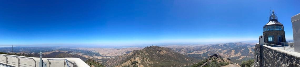
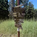
The visitor center was fully open, so for the first time in a year and a half I was able to actually set foot on the EXACT summit of Mt Diablo. They built the summit building around the actual summit, so there’s a little patch of rock that you can step on. But the building has been closed due to the pandemic, so this little summit tradition of mine could finally be done again.
Because of the heat still being a big concern, I ended up buying a couple of COLD cans of Diet Coke and new bottle of Gatorade. I drank one of the Diet Cokes as I rested in the shade and thought about calling for a Uber. 🙂
I somehow got the energy to shake off that thought and start down the trail. again, the upper part was mostly in direct sunlight and took a lot out of me. I took a very long break at the junction and even longer at Live Oak Campground. Even the shade of the lower parts of the trail didn’t help beat the heat.
It ended up taking me 11 hours to go up and down. A hike that usually takes me around 6hours. Granted, 3 of those 11 hours was for the extended rest stops, but that’s still a very long day and a lot of extra time in the heat. I had pretty much used every drop of my 4 liters of water plus 3 bottles of Gatorade by the time I got back to my Jeep. As I said, a VERY hot day.
But at least I pushed through and didn’t give up.
After getting exhausted at Mt Diablo, I decided to… go back to Mt Diablo the next weekend. 🙂
The main reason was to stay overnight in the park so I could see the sunset and sunrise from Mt Diablo. Mostly to do some final tests on my new Sony ZV1 camera that I didn’t get to do a full try out in my aborted Yosemite trip, but it’s also a great place to see the sunset and sunrise. I had a week left to return the camera if I didn’t like it.
So, I got a good site at the Juniper Campground and decided I’d probably see the sunset from there since it had a great view to the west. For sunrise, I pretty much had to go to the summit for the best view.
Technically, I didn’t have to do any hiking for any of this since I can drive to the campsite and summit. That would be the easiest thing to do.
But I don’t always do the easiest thing (much to my feet, legs, and body’s regret).
I decided to do the Mt Diablo Grand Loop since it started and ended inside the park and passed right through Juniper Campground. I also wanted to do it as sort of a homage to my breakthrough hike.
It was back in 2012 when I was still just doing short day hikes around the area and found the Grand Loop listed on a website. It circled the summit and covered a lot of different areas of the park. At less than 8 miles, it seemed like it was in my range at the time.
But I didn’t look at the map closely enough to see that it was almost 2,800 of elevation to descend AND re-climb as you did that loop. Back then, it exhausted me, but I actually made it the whole way.
After that, I started to think some of the bigger climbs weren’t impossible for me after all. The 2,800 foot climb was only a bit less than the 3,200 feet that you had to climb up to the Mt Diablo main summit along the Summit Trail. So, with that in mind, I started doing longer and higher hikes, including doing the Summit Trail in two parts to work my way up to the point where I could try to do the whole mountain at once.
Before that I assumed that the only way that I’d be able to do the entire Summit Trail was to start at the top, climb down, and get an Uber back to the top. So, when I did finally do the entire Summit Trail up and down in one day hike the next year, it opened a whole new world for me. Salkantay to Machu Pichuu, Half Dome, Mt Whitney, Kilimanjaro, and the entire John Muir Trail can all be traced back to my successfully completing the Grand Loop at Mt Diablo.
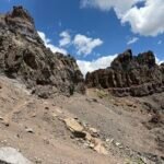
So nine years later, I decided to do this hike as a little tribute to that moment when my view of what I could do changed drastically. I got an early start from the Juniper Campground and headed down the steep trail to Dear Flat. Then the climb UP to Meridian Ridge began. You’d think since I’d done these trails many times before and I knew what was coming would not make me curse the trails or my decision to do this as I hiked, but nope… 🙂
After taking a nice long break before going up the Bald Ridge Trail and having a fleeting thought about popping over to Eagle Peak (I’m a glutton for punishment), I started up the second steep climb of the day. Bald Ridge was a lot funner when hiked in the downward direction. 🙂
By the time I reached the junction with the North Peak Trail I had already decided not to go up to North Peak as a detour (I learned my lesson when I had that fleeting thought before), so headed up the North Peak Trail towards the Main Summit. This trail wasn’t particularly steep, but did wrap around the south side of the mountain so was a bit annoying since you could see the summit building all along the way taunting you with how close it looked.
So for the second time in two weekends, I set foot on the main summit and celebrated with a cold Diet Coke.
From there, I just had to descend to Juniper Campground and setup my tent. I was sure that meant going down the Summit Trail until it hit the lower part of the Juniper Trail, which I would then hike horizontally over to the campground.
I was tempted to save about a mile of hiking and maybe 200-300 feet of re-climbing by just going down the Juniper Trail directly from the lower summit parking lot, but I was sure the Summit Trail was the correct route and I wanted to do the proper loop that I remembered doing nine years earlier.
I ended up doing the longer route and then when I later looked up the route online, I found that the shorter Juniper Trail route was the official part of the ‘Grand Loop’ after all.
Memory is a bitch sometimes.
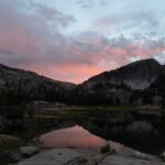
Regardless, I felt satisfied at doing a nice long hike as I setup my tent and then made my dinner. As sunset neared, I setup my chair at a nice open area and setup one my older Sony HX90V camera to record a movie of the sunset that I could create a time lapse video of later. I would use my iPhone and Sony ZV1 for various pictures and panoramas of the sunset.
The sunset was everything I remembered from the first time I stayed overnight at Mt Diablo. There were a few bands of clouds to the west, but not enough to hide the sunset and just enough to enhance it. I went through a lot of different settings on my new Sony ZV1 camera trying to to find the best way to capture the light from the sunset and was actually pretty happy with the results.
After a thoroughly enjoyable sunset, I settled into my tent and tried to go to sleep as early as possible since I knew I’d have to be up around 5am to drive to the summit for the sunrise.
Unfortunately, I had a rough night and didn’t get much sleep.
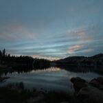
I wasn’t going to keep that from stopping me from seeing the sunrise. I did take a very slow drive to the summit making sure I didn’t drive over the edge of the road, which on Mt Diablo could be a VERY long drop.
I had the summit to myself as I setup my camera for the time lapse and enjoyed some donuts for breakfast.
Unfortunately, there were quite a lot of clouds covering the eastern sky that blocked a good deal of the morning light. Not entirely, so I did get some glimpses of the sun and various beams lights peeking through the clouds all around me.
Not a perfect sunrise, but an enjoyable way to start my day.
I drove back and packed up my tent and made my way home.
So a pretty good weekend, but tiring in more ways than one.
You can see the results of my camera tests below. I plan to keep the Sony ZV1 for my main camera.
Colorado beckons me in August. Wish me luck.
For the last day in July I decided to take an easy hike around Briones Ridge. It’s a routine hike for me since it’s close to home and a good workout with many loop options depending on how I feel.
The start is the worst part, since you’re climbing up about 600 feet in a very short span. I started out with low clouds covering the area, but they soon burned off and let me see the 360 view from the ridge.
When I took a break near Old Briones Road, I saw a coyote yelling up a storm. Seemed like he didn’t like some of the dogs passing by on the trail.
I could have loop back to the start, but decided to continue to Birones Peak and then all the way to Seaborg Trail. There I decided to save 1.5 miles of hiking by not going to Russell Peak and returned to my Jeep via Seaborg Trail. A nice 8 miles in a little over 4 hours.


Comments by WanderingJim
PCT DAY 85 – CA Section H
"No cell service in many parts of the PCT. Not dead yet."
PCT or BUST!
"Yes, I’ll be going through there by early August"
JMT 2020 Day 3
"I'm afraid I have no idea. Not really a fisherman, so don't..."
JMT 2020 Trek Day by Day
"Yeah, but with 9,000 pictures, it's hard to label each one..."
Kilimanjaro – October 2019
"Everest Base camp is on my list too. Mostly since I know..."